A reconnaissance of the ice-free valleys in southern Victoria Land, Antarctica was undertaken during the last portion of the 1982-1983 field season to select sites where long-term exposure studies will be conducted during subsequent years. The purpose of these long-term studies is to quantify the nature and rate of physical and chemical weathering mechanisms currently operating in the dry valleys.
In addition to the survey of potential test sites, a single, limited experiment was conducted to proof-test hardware and deployment techniques. Although the results of the winter experiment will yield far more valuable data, results from this 16-day deployment are promising and consistent with laboratory and field studies in other areas.
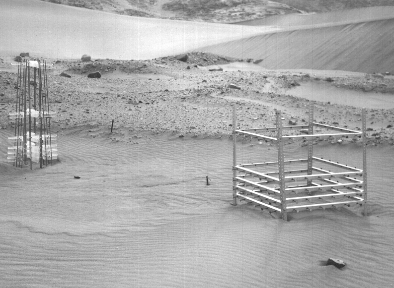
The single test site was deployed on 10 January 1983 and partially redeployed on 26 January 1983. The site is located at the southern margin of the field of sand dunes in eastern Victoria Valley east and slightly north of Lake Vida (Calkin, 1964, 1971; Calkin and Rutford 1974; Lindsay 1973; Selby et al. 1974). The site is approximately 1.8 kilometers SSE of the tip of Packard Glacier (not visible from site) at 77o22'30"S 162o09'30"E. Sand collectors were deployed at nominal heights above mean ground level of 7, 14, 21, 35, 70, and 140 centimeters, facing the four cardinal directions. Abrasion targets of basalt, nonwelded tuff, and sandstone, 2.5 centimeters in diameter and mounted on 7.6-centimeter "elevator bolts," projected 6 centimeters out from an aluminum framework that held them at nominal heights of 7, 14, 21, 35, and 70 centimeters above mean ground level. These targets also faced north, east, south, and west. Figure 1 shows the site prior to collection of samples after 15.69 days exposure. Two samples of each material were deployed at each height and in each direction. One of each pair was returned in January; the other will be examined after next season. The results reported here are for the initial, short-term sample.
15 KBytesFigure 1: Abrasion test site, Victoria Valley dunes. Sand collectors on left, abrasion targets on right. Target holder is 1 meter square.
Figure 2 shows the material trapped by the sand collectors for each height from which a measurable amount of sand was recovered. The smallest measured amount was 0.12 grams at 140 centimeters height-losses from other samples did not greatly exceed this minimum recovery. The relative mass as a function of direction (north equaled 12%, east equaled 64% south equaled 2%, and west equaled 22%) reflects the directional frequency of winds capable of transporting sand during the collection period. Without continuous anemometry, only estimates of wind speed are possible-during 5 days of observation, sand-moving wind speeds averaged approximately 28-32 kilometers per hour, with particles probably moving about 80-90 percent of that speed (approximately 5-8 meters per second) (Greeley et al. 1982).
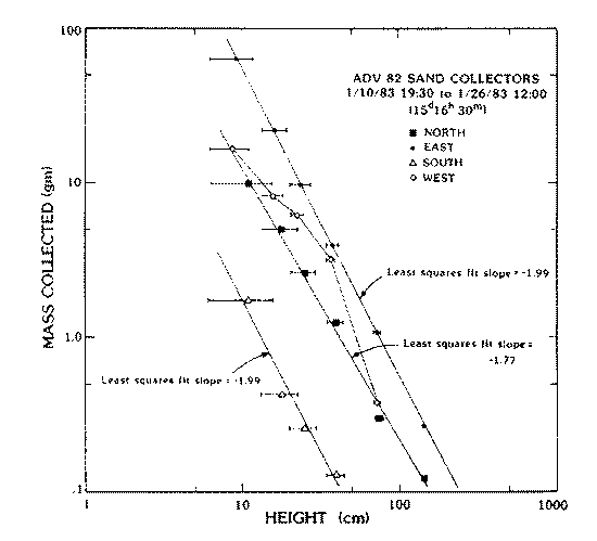
Figure 2: Mass (in grams) trapped by sand collectors as function of height (in centimeters) above ground for four cardinal directions, in 15.69 days (15 days, 16 hours, 30 minutes). Bars reflect change in mean ground surface caused by movement of ripples through site.
Five control specimens of each of three types of material (basalt, non-welded tuff, sandstone) were transported to Antarctica and returned without exposure. These samples experienced mass changes of 3-15 milligrams, averaging about 5 milligrams for the basalt and sandstone and 8 milligrams for the non-welded tuff. As a conservative criterion, only abrasion targets that exhibited mass losses in excess of 10 milligrams were used to determine abrasion rates. Ten tuff (north at 7, 14, and 21 centimeters; east at 7, 14, 21, 35, and 70 centimeters; south at 7 centimeters; and west at 7 centimeters), three basalt (north at 7 centimeters, east at 7 centimeters, and west at 7 centimeters), and no sandstone specimens met this criterion. Largest mass loss for the tuff was 51 milligrams (east at 7 centimeters) and for basalt, 16 milligrams (east at 7 centimeters). Average susceptibility to abrasion (mass lost/mass flux, normalized for area and time) for the tuff was about 2.5 X 10^-3, and for the basalt about 2 X 10^4, comparable to values determined in laboratory (Greeley et al. 1982) and other field studies.
Average abrasion mass loss within the lower portion of sand movement (less than 15-25 centimeters) was approximately 3.8 X 10^-4 grams per square centimeter per day for the tuff and 1.7 X 10^-4 grams per square centimeter per day for the basalt, equivalent to an average loss of 3 micrometers and O.7 micrometers per day, respectively. The values represent approximate maximum rates of abrasion in the present ice-free areas and are restricted to locations of abundant, mobile surface sand. Better knowledge of the frequency of winds (i.e., number of days that winds blow at average determined for 16-day test) and observations in areas of lower sand flux are needed before these rates can be used to assess past abrasional environments. Sites to be established during the 1983-1984 field season will acquire these data over necessarily extended periods of exposure.
Calkin, P. E. 1971. Glacial geology of the Victoria Valley System, Southern Victoria Land, Antarctica. In A. P. Crary (Ed.), Antarctic snow and ice studies 11, (American Geophysical Union Antarctic Research Series No. 16). Washington, D.C.: American Geophysical Union.
Calkin, P. E., and R. H. Rutford. 1974. The sand dunes of Victoria Valley, Antarctica. Geographical Review, 64(2), 189-216.
Greeley, R., R. N. Leach, S. H. Williams, B. R. White, J. B. Pollack, D. H. Krinsley, and J. R. Marshall. 1982. Rate of wind abrasion on Mars. Journal of Geophysical Research, 87(B12), 10,009-10,0)24.
Lindsay, J. E. 1973. Reversing barchan dunes in Lower Victoria Valley, Antarctica. Geological Society of America Bulletin, 84(5), 1799-1806.
Selby, M. J., R. B. Rains, and R. W. P. Palmer. 1974. Eolian deposits of the ice-free Victoria Valley, Southern Victoria Land and Antarctica. New Zealand Journal of Geology and Geophysics, 17(3), 543-562.