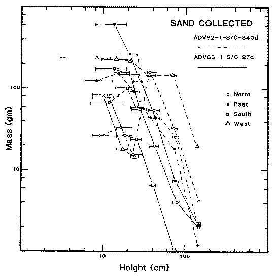
Figure 1: Sand collected as a function of height, at site 1 in the Victoria Valley dune field. "Error" bars Indicate actual range in height of collectors relative to ground surface, which varied owing to sand migration during experiment. Solid lines (27-day experiment) show power-law form similar to that seen in 1982-1983 data. Dashed lines (340-day experiment), show power-law form for higher collectors, but fall off at lower heights, indicating that the collectors were not able to sample the low-velocity portion of the saltation zone properly. ("gm" denotes gram; "cm" denotes centimeter.)
The relationships between mass and height determined from the sand collected over the 340-day exposure are significantly different from those seen in the short-term collections. The long-term experiment data display a distinctly non-power law shape; it is not fit by any simple function. Although this could possibly be the actual form of the mass/height relationship, it is more likely that it arises through the inability of the collectors to sample the flux properly because of aerodynamic "back pressure" and/or turbulence at the collector entrances, possible clogging for periods of time, or other phenomena associated with wind or sediment interaction with the collectors. Mass loss from abrasion targets, discussed below, suggests higher fluxes in the near-surface zone than were actually collected. In evaluating the abrasion environment, -2.0 and -2.5 power-law functions were fit to the masses collected at 35-, 70-, and 140 centimeter heights. Estimates were then computed for mass flux at lower heights, and abrasion rates were determined with these calculated values. Comparison of the amount of abrasion thus determined with actual amounts of abrasion for the upper two or three samples (70, 35, and 21 centimeters) indicate that the power-law assumption is probably valid.
Mass loss from rock targets of a given composition varied as a function of height and azimuth, reflecting a complex interaction of variables including the distribution of particles as a function of size, height, and wind speed, direction, and cumulative duration. Without simultaneous anemometry, it is not possible to deconvolve the components of the flux; however, some average values can be determined and are reported here.
Mass loss from basalt and sandstone targets averaged about 25 milligrams; non-welded tuff targets lost an average of about 290 milligrams (e.g., Figure 2). These mass loss values are significantly above the "noise" level determined by transporting but not deploying identical samples (approximately 5 milligrams for basalt and sandstone, 10 milligrams for tuff). Amounts of abrasion and sand collection are consistent with 20 percent of sand-moving winds coming from the north, 15 percent from the east, 25 percent from the south, and 40 percent from the west, for the 340-day period. Average mass loss, normalized for area and time, was 2.2 X 10^-5 grams per square centimeter per day (basalt), 1.7 X 10^-5 grams per square centimeter per day (sandstone), and 1.4 X 10^-4 grams per square centimeter per day (tuff). Maximum rates were 2.8 X 10^-5, 4.2 X 10^-5, and 6.6 X 10^-4 respectively. These average values are from 2 to 7 times lower than those computed from last season's 16-day exposure, although the maximum rates are closer. The average rates are equivalent to a daily abrasion of 0.1 micrometers for the basalt and sandstone and 1.5 micrometers for the tuff, or about 30 and 500 micrometers per year, respectively.
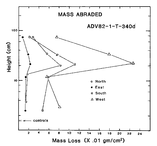
Figure 2: Mass abraded from non-welded volcanic tuff (from Bishop, California) during 340 days of exposure at the VIctoria Valley dune field. Mass loss as a function of height Is similar to that first observed by Sharp (1964) with the maximum abrasion occurring at a height of 20-25 centimeters. Lower samples may have been buried for part of the duration of the experiment. ("gm/cm^2" denotes grams per square centimeter; "cm" denotes centimeter.)
As part of a long-term study of physical and chemical weathering mechanisms in the ice-free valleys of south Victoria Land, Antarctica, 10 test sites have been established in different micrometeorological, topographic, and sedimentological environments within Victoria, Wright, and Taylor Valleys. An eleventh site was emplaced approximately 8 kilometers west of the Allan Hills, on "blue ice," to assess chemical and physical processes that may have affected meteorites collected in the area. The table (below) gives the positions of the 11 sites.
Location of weathering and abrasion test sites southern Victoria Land, Antarctlca
Site	   Latitude    Longitude  Altitude       Name
				 (in meters)

ADV83-1   77o22'39"S  162o10'00"E    375   Victoria Valley Dunes
ADV83-2   77o23'58"S  161o51'11"E    380   South of Lake Vida
ADV83-3   77o26'34"S  161o37'45"E    750   Bull Pass
ADV83-4   77o21'57"S  161o58'36"E    750   North of Lake Vida
ADV83-5   77o26'26"S  162o04'48"E  1,075   Olympus Range, Lake
					   Thomas Basin
ADV83-6   77o25'40"S  162o42'11"E    280   Lower Wright Valley
ADV83-7   77o30'46"S  162o06'11"E    250   Central Wright Valley
ADV83-8   77o32'18"S  161o06'23"E    150   North Fork, Upper Wright
					   Valley
ADV83-9   77o43'20"S  162o19'24"E    175   Bonney Riegel, Taylor
					   Valley
ADV83-10  77o36'46"S  160o52'13"E  1,600   Asgard Range, Cirque 4
					   Upper Wright Valley
ADV83-11  76o42'00"S  159o24'30"E  2,000   Approx. 8 km east of
					   Allan Hills on "blue
					   ice"
Each site consists of racks of rock disks (0.5 centimeters thick by 2.5 centimeters diameter) mounted on bolts, facing true north, east, south, and west at nominal heights of 7, 14, 21, 35, and 70 centimeters above the ground. Three materials are present at each site: basalt, native dolerite, and non-welded volcanic tuff. Sand collectors, arrayed in a similar manner and at the additional height of 140 centimeters, are also part of each site in the valleys. Five cubes, 7.5 centimeters on a side, cut from native granite, and five cylinders (2.5 centimeters long by 2.5 centimeters diameter) of native dolerite, were also deployed at each site. The return of these materials, along with rock cores drilled from outcrops and boulders, and their laboratory analysis, constitute the principal activity of this project. Exposures will range from 1 year to as much as 40 years.
These values are consistent with similar observations in Iceland in an area of high sand flux. There, abrasion results have been successfully used to examine age relationships between deposits of catastrophic floods (Malin and Eppler 1981a, 1981b). As the results for the test sites in the ice-free valleys become available, it should be possible to assess their usefulness in dating glacial deposits.
Acknowledgments
M. C. Malin and D. B. Eppler conducted the field portion of this study from 19 November 1983 to 24 January 1984, retrieving materials deployed in 1982-1983 by M. C. Malin and S. Williams. D. Michna ably performed the many sand and sample measurements. We are especially indebted to the helicopter pilots and crews of VXE-6, who provided considerable assistance in site selection and experiment deployment. This research is supported by National Science Foundation grant DPP 82-06391
References
Malin, M. C. and D. B. Eppler, 1981b. Catastrophic floods of the Jokulsa a Fjollum, Iceland. (Abstract.) In H. Holt (Ed.), Reports of Planetary Geology Program - 1981. (NASA Technical Memorandum 84211) Washington, D.C.: U.S. Government Printing Office.
Malin, M. C. 1984. Preliminary abrasion rate observations in Victoria Valley, Antarctica. Antarctic Journal of the U.S., 18(5) 25-26.
Sharp, R. P. 1964. Wind-driven sand in Coachella Valley, California. Geological Society of America Bulletin, 75, 785-804.