 |
|
|
The Mars Observer Camera (MOC) will be the first U.S. camera at Mars since the Viking Orbiters ended operations in 1980. It was originally designed for the Mars Observer mission, which was launched on September 25, 1992. The first MOC, MOC1, functioned for almost a year in space, taking a series of cruise calibration images culminating in two images of Mars from a distance of about 6 million kilometers. About one month after those images were taken, contact with Mars Observer was lost, shortly after the spacecraft was commanded to pressurize its propulsion system in preparation for insertion into Mars orbit.
Following the loss, NASA decided to fly a new mission, Mars Global Surveyor (MGS), which would carry the MOC flight spare (now called the Mars Orbiter Camera or MOC2) and copies of some of the other MO instruments. MOC2 is nearly identical to the instrument that flew on MO. MGS is to be launched on a Delta 2 booster in November 1996.
Here, we discuss what the MOC does and some of the science goals we hope to address with it. (This is a short version of the detailed discussions found in the papers Design and Development of the Mars Observer Camera and The Mars Observer Camera.)
Physically, the MOC is a cylinder about three feet (88 cm) high by 16 inches (40 cm) in diameter. The main structure is entirely built of graphite-epoxy, a lightweight composite material. The MOC has three optical systems; the Narrow Angle (NA) system, which is a 35-cm (14 inch) diameter f/10 reflecting telescope with two redundant 2048-pixel CCD detectors, and two Wide Angle (WA) systems, one with a red filter and the other with a violet filter, which are "fisheye" lenses with 140-degree fields of view and 3456-pixel CCD detectors. The WAs are mounted on the side of the cylinder, and the electronics, on circular circuit boards, are housed in an aluminum cylinder fixed to the base. The MOC weighs about 40 pounds (20.5 kg) and consumes about 19 watts of power with all cameras active. It takes images at a rate of 40 megabits/sec (Mbps) and can transmit it to Earth at a maximum rate of 128 kilobits/sec (Kbps). By way of comparison, the cameras carried by the Viking Orbiter spacecraft weighed 90 pounds (40 kg), used 46 watts, took images at 5 Mbps and transmitted it at only 8 Kbps.
The NA has a field of view of 0.44 degrees; from the surface of the Earth, a MOC image would nearly cover the face of the Moon. From the mapping orbit of MGS, it covers an area 3 km (1.8 miles) wide; each pixel covers an area 1.4 meters (4.6 feet) square.
The WAs see from one visible horizon of Mars to the other from the mapping orbit. Directly beneath the spacecraft, each pixel is about 230 meters (755 feet) square. This wide field of view allows the WAs to map the entire planet every day.
Because all of the cameras are "line-scan" systems, the images can be as long as will fit into the camera's memory. A typical NA image will be from 2048 to about 8000 lines high. In addition, summing modes can be used to add pixels together, reducing the size of the image but decreasing its resolution.
The image on the left is a simulated MOC WA context image at a resolution of about 230 m/pixel (based on Viking image 629A02.) On the right is a simulated MOC NA image, taken in the 8x8 summing mode, with a resolution of about 11.2 meters/pixel. (It was based on Viking image 758A68.) The area covered by the NA image is shown as a white box in the context image.
At full resolution, the NA will show eight times the detail seen above. The only areas on Mars that we have seen at this resolution are the Viking Lander sites; we can only guess if these places are typical of Mars. The MOC's resolution is high enough to see large boulders, such as those in this aerial photo of terrain in Antarctica:
 Antarctica at MOC resolution
One other point must be mentioned: the lighting conditions. Viking images were usually taken at low sun angles, meaning that it was near dawn or dusk at the place being imaged. For example, the images above were taken in the late afternoon, at about 5 PM local time. The MGS spacecraft is in an orbit at a mean local time of 2 PM. This means that in general, shadows will be shorter and contrast will be lower in MOC images.
The MOC provides two capabilities that previous instruments sent to Mars have lacked. The first is the very high resolution of the NA, which is almost 10 times higher than the best images taken by Viking. The second is the repetitive coverage provided by the WAs. As we saw with the polar cap movies, Viking could take enough images to cover a large area such as the polar regions only a few times a month, at best. The WAs will return an image containing every point on the planet once a day, and areas near the poles can be imaged on every orbit.
The science objectives for the Mars Observer Camera investigation fall into two broad categories: meteorology/climatology and geoscience. The meteorology/climatology category includes observations of clouds, dust, variable surface features, and wind patterns. Geoscience will include observations of the details of surface landforms (for example, channels, layered deposits, etc.) with emphasis on how they were created (for example, by wind or fluid flow, landslides, etc.)
In general, the NA will be used for geoscience, and the WAs for meteorology/climatology, but there will be instances where the reverse will be true.
Meteorology is what the weather conditions are like today; climatology is how the pattern of the weather changes over longer periods. Today, the weather on Mars is dominated by the annual variation of carbon dioxide as it freezes and sublimes at the poles, causing global changes in the atmospheric pressure. But evidence suggests that Mars may have had a significantly denser atmosphere, and perhaps even liquid water, at some point earlier in its history. By carefully examining the weather on Mars over an entire martian year, we hope to gain more insight into how the climate may have changed over time.
The most obvious meteorological phenomenon to be seen in weather satellite images of the Earth are the clouds. Clouds provide the simplest means of tracing the motion of weather systems on a planet. The same is true on Mars, although clouds are far less prevalent there than on Earth. Clouds act as tracers of water vapor, helping to locate long-term sources and sinks of water.
 Water Ice
Cloud (Viking image 088A03)
Water Ice
Cloud (Viking image 088A03)
The MOC WA will see cloud patterns moving on a daily basis; in the polar regions, where the spacecraft can image every two hours, cloud tracking will be even better. The color capability of the WA can be used to discriminate condensate clouds (water and CO2) from dust: condensates tend to be whitish, while dust is more red or yellow.
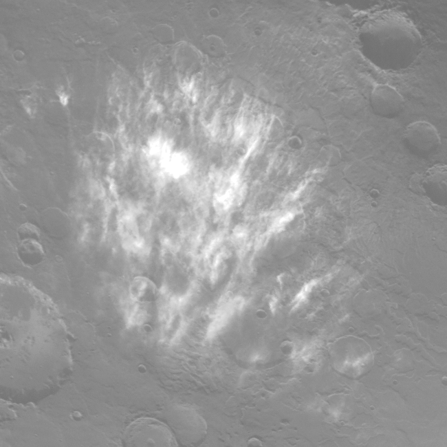
There are two general types of dust storm on Mars: local storms, which are cover only a fairly small area, and global storms which grow to cover the entire planet. Local storms are caused by brief periods of high wind; they also indicate differences in the type, size, and amount of dust on the surface. Global dust storms result from longer periods of high wind; the dust is carried to very high altitude and blown all around the planet, taking long periods of time to settle out. In its global monitoring mode, MOC will catch numerous local dust storms during the dust storm season. Over periods of a week or more, daily maps will capture the entire life cycles of such storms. With luck, MOC images will also document the entire growth phase of a global dust storm.
There are many areas on Mars that change color during the year. These variable surface features may be "streaks" -- long, linear patterns -- or "splotches" -- irregular, usually dark areas often found in or near craters. Some splotches are dune fields; others are less identifiable. These variable surface features show that both dark and light material can be carried by wind, and are good indicators of wind direction.
 Wind
Streaks (Viking image 041B51)
Wind
Streaks (Viking image 041B51)
 Intercrater
Dune "Splotch" (Viking image 094A47)
Intercrater
Dune "Splotch" (Viking image 094A47)
By regularly mapping the surface at a variety of resolutions during an entire year, MOC images will provide an excellent record of the seasonal changes.
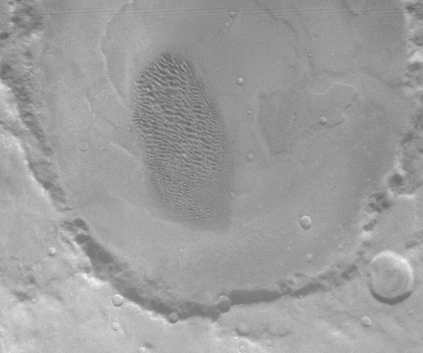
As we have seen, the waxing and waning of the carbon dioxide polar caps is the most important annual change on Mars. The permanent polar caps are not composed of CO2, but of water ice: the permanent caps are the largest observable mass of water on the planet. The enigmatic polar layered deposits have been used as evidence for major changes in climate throughout martian history.
 North
Polar Layered Deposit (Viking image 056B84)
North
Polar Layered Deposit (Viking image 056B84)
The MOC will be able to observe the layered deposits at vary high resolution, helping to understand how they formed. It will also observe the processes by which the caps grow and shrink annually.
The Viking Orbiter images have already permitted geoscientists to learn a great deal about the planet. While the climatological goals mostly require more frequent observations at fairly low resolutions, the Viking Orbiter images allow the geoscience goals to be very specific, addressing the fundamental questions of how features formed on the planet with limited amounts of additional data. Typically, these will be small numbers of NA images, taken of specific types of features such as channel floors, volcano flanks, craters, dunes, and canyons.
We have seen that the forms of the martian channels and valley networks suggest that these features were formed by water, which must have been more prevalent earlier in martian history. However, the exact mechanism of how they were formed remains unknown, and other fluids (wind, lava, and ice) have occasionally been suggested as alternatives.
The MOC will provide a way to test these alternative ideas, primarily by examining the size distribution of debris found in the channels and valleys. For example, if the outflow channels were formed by catastrophic floods, then the size and distribution of meter-sized objects can be used to determine the water's velocity and depth, allowing an estimate of the amount of water to be made.
Direct observation of small, wind-shaped features such as ripples and dunes can be used to determine the particle size and abundance of dust and sand. MOC images can be used to examine fine detail on these features, which is only hinted at in Viking images.
Visitors to Volcanoes National Park on the Big Island of Hawai`i are struck by the two radically different textures of lava flows -- the very rough, "clinker" a`a flows and the smooth, almost glassy pahoehoe flows. Despite their different appearance, the initial composition of the molten lava was identical; the a`a texture is caused by turbulence within the lava as it descends steep slopes, by crystallization within the lava, or by volatiles such as water being lost as the lava flows. MOC images should permit the direct observation of these textures and the boundaries between them, helping us to understand the specifics of the formation of the martian volcanoes.
On Earth, study of the sedimentary layers in canyons provides one of the most important records of the history of an area. The gigantic Valles Marineris canyon system, penetrating as much as 10 kilometers below the surrounding surface, reveals the most ancient rocks on Mars. But landslides and possibly volcanic deposits also show that the canyons are not static, but evolving. MOC images will address the questions of how the canyons formed, and show the nature of the sedimentary rocks within them.
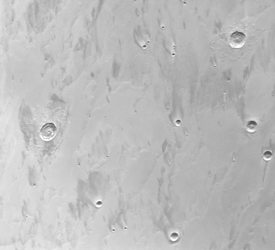
Craters are the single most useful probes of planetary surfaces, allowing the dating of the surface and estimates of its properties. Craters appear on the Viking images at even the highest resolutions; smaller craters are newer, in general, providing a view of recent evolution. MOC images should show craters all the way down to meter scales.
The Viking Orbiters were used to find smooth, safe landing sites for the Viking Landers. The Viking team was quite surprised to discover that the landing sites were actually covered with meter-scale boulders which had been invisible from orbit. Many of these boulders could have destroyed a lander coming down on top of them. While the next U.S. lander (Mars Pathfinder) will have to "take its chances", it seems likely that future missions, such as the Mars Surveyor '98 Lander, will rely on MOC images to assess the safety of potential landing sites.
The MOC will provide our best view ever of the red planet. By returning daily "weather satellite" coverage, combined with extremely high-resolution closeups of selected areas, many unanswered questions about Mars can be addressed and perhaps answered. And as with all exploration, the most exciting part of the mission will be the things we don't expect. All of us are looking forward to that.
Mike Caplinger (mc@msss.com)
 The Mars Observer Camera
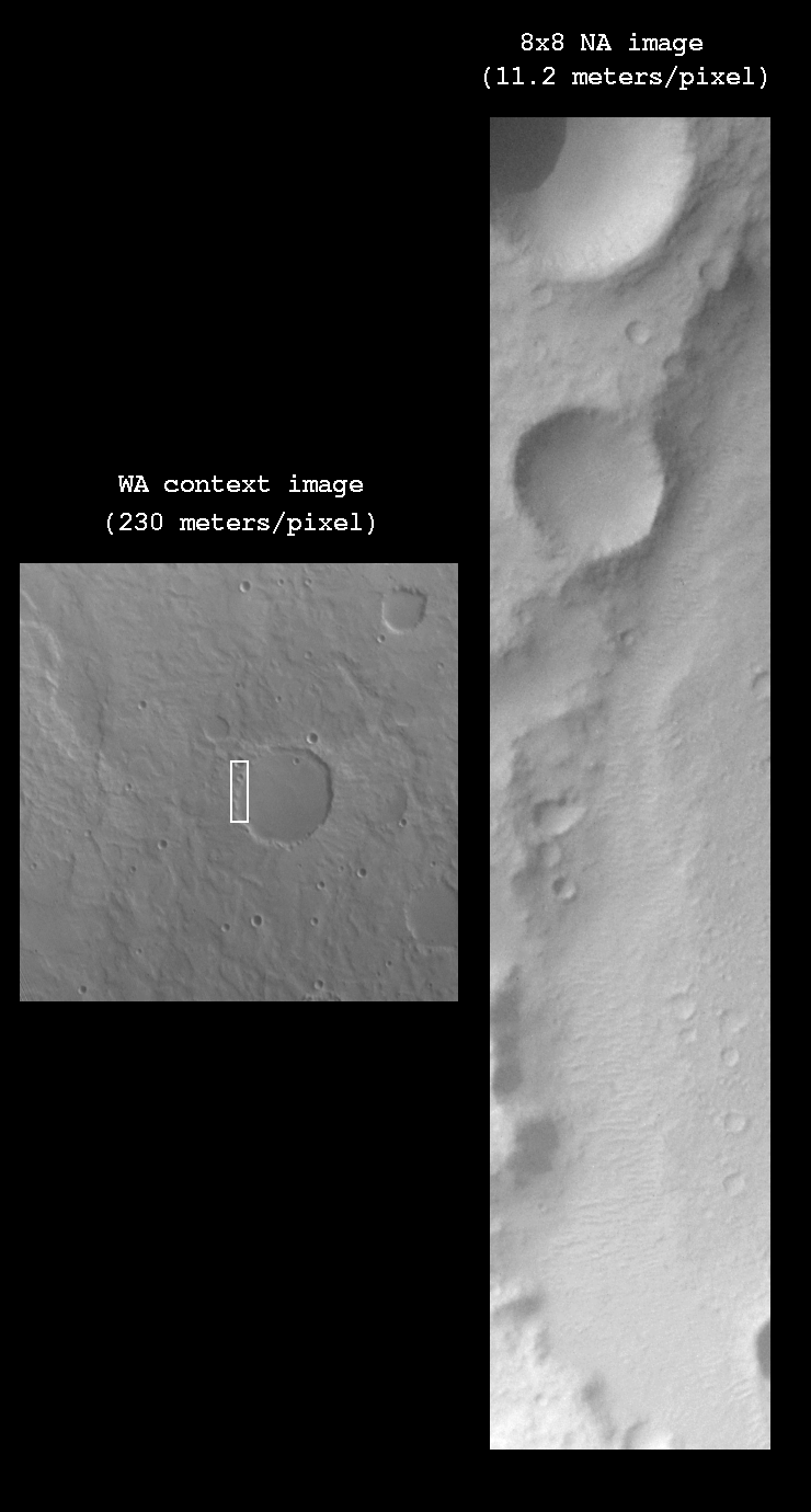 A Simulated MOC Image