 |
|
|
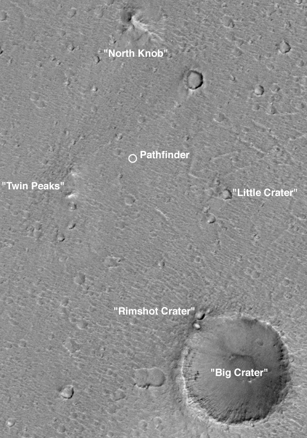 The 1997 Mars Pathfinder landing site in context of Mars Global Surveyor MOC image SP1-25603.
|
The Phoenix Mars Descent Imager (MARDI) will provide a context in which all other Phoenix observations can be fully understood.Among the most important questions to be asked about a spacecraft sitting on a planet is "Where is it?" To some extent, this question can be answered by tracking a lander's radio signal, both from Earth and (if available) from an orbiting spacecraft. Internal measurements made by the lander during its descent to the surface also help pin down the location. At best, these techniques can tell the position of the spacecraft relative to the center of the planet to perhaps a hundred meters (~100 yards). Tying these positions to the surface, however, requires correlation with longitude and latitude networks, which are often inaccurate to hundreds if not thousands of meters. Surface imaging of features also visible from orbit can be used to pinpoint lander positions to a few tens of meters or better, provided that such features are found (as was the case for Pathfinder--see left). However, if the orbiter image resolution is insufficient to see features visible to the lander, or the local, meter-scale relief is too great (so the lander cannot see very far), or the surface is relatively featureless, or the surface has many features but they all look the same, then the lander cannot be located, or its location may be misidentified.
|
The 1976 Viking Landers and the 1997 Mars Pathfinder provide good examples
of such
circumstances. Through a combination of 20-40 m/pixel (65-130 ft/pixel),
high quality orbiter
photography, excellent radio tracking from Earth over a long period of time
combined with good position measurements during landing, and fortuitously
landing near craters and hills large enough to be seen on the horizon in
lander images, Pathfinder was located to within about 40-50 meters (130-165 ft)
(e.g., see the July 1998 release showing
Location of Mars Pathfinder in a MOC image). Later high-resolution imaging
of course, showed the locations of all previous U.S. Mars landers: |
 What if you landed in a crater and couldn't see out? The scenario depicted in This cartoon, created in 1999 by M. C. Malin, came true in 2004 when the Mars Exploration Rover, Opportunity, landed in Eagle Crater.
|
On the other hand, despite good position measurements during landing and good radio tracking both during the descent and for a number of weeks thereafter, the location of the Viking 2 lander was not known to better than about 10 kilometers (~6 miles), until it was identified in a MOC image obtained in 2004, because the terrain is homogeneously rugged, the horizon is nearly featureless, and Viking Orbiter images had poor resolution in the region that included the lander. It can therefore be quite difficult to identify the location of a lander, especially on a quick time scale so that knowledge of the location will assist in the scientific conduct of the mission, without using a descent imager.
|
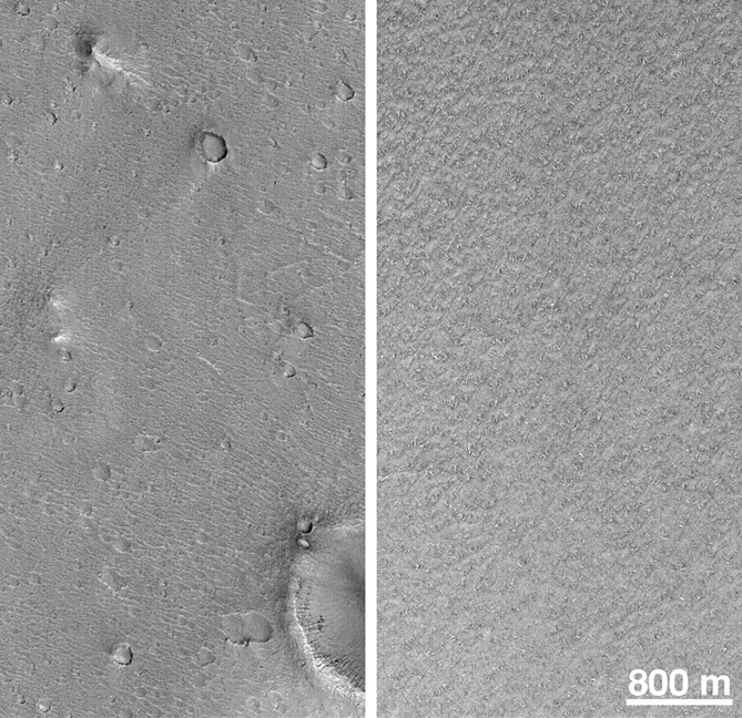 Mars Global Surveyor MOC images comparing the Mars Pathfinder site and a representative Mars Polar Lander landing zone surface.
|
Why is it important to know "exactly" where a lander is located?The principal reason is "context." It is important to determine if the locale is representative of the region, and of the rest of the planet. It is usually not possible, just from a lander's perspective, to tell the difference between what is visible and what is just over the horizon. The locale may be unusual, and this must be determined before general interpretations can be made. The context of relating lander observations to those seen from an orbiter is also important. The simplest, and most obvious, example is to place surface imaging into the context of orbiter images (e.g., extending surface and orbiter observations of ripples and dunes, cobbles and boulders, etc.). Other examples include relating color and/or albedo boundaries seen in orbiter data down to lander scales (which is particularly difficult to do from the surface owing to the extremely oblique viewing geometry of lander instruments), and providing data to test techniques used to assess the surface of planets using thermal infrared measurements.
|
Descent imaging can also provide a context for operations after landing. For example, the final images can cover the area around the lander out to several tens of meters or more at spatial scales of a few centimeters. Such images can be used to plan sampling activities and/or rover traverses, both initially before surface imaging, and complimentary to those data once they are received. The easily interpreted, overhead perspective provides such planning activities considerable speed and flexibility. Advanced techniques in computer graphics and data visualization can be used to merge lander images with distance measurements, derived from stereoscopic images or laser rangefinding, in efforts to mimic the overhead perspective. However, the inability to see surfaces hidden from direct view from the lander perspective is an essentially fatal flaw in such efforts. The simplest, most comprehensive way to achieve overhead viewing is from a descent camera.
|