Introduction
Continuing research on the nature and rates of geomorphic processes in ice-free areas of southern Victoria Land concentrated during the 1984-1985 austral summer on recovering samples from 11 sites established the preceding year (Malin 1985). Over 600 abrasion targets and 240 sand-trap specimens were recovered after exposure for 1 year. Significant damage to sand collectors and visible abrasion of targets at several sites attest to strong winds of consistent but short duration. Calculations suggest free-stream wind speeds approaching 70 meters per second (250 kilometers per hour; 155 miles per hour).Preliminary results from one site, antarctic dry valley (ADV) site 1, within the dune field in eastern Victoria Valley, were reported earlier (Malin 1984, 1985). This article reports on a comparison of 2 consecutive years at that same site and on some preliminary studies of other geomorphic features. A full report on the initial results for the other 10 sites is presently in preparation.
Abrasion in the Victoria Dunes
The test site is located at approximately 77 deg 22'S 162 deg 10' E at an altitude of 375 meters. It is approximately 1.8 kilometers south-southeast of the tip of Packard Glacier, about a third of the way from the dune field crest toward the stream connecting Victoria Lower Glacier with Lake Vida. First results for a short-term (16-day) exposure indicated a maximum annual abrasion rate for rocks exposed to dune sand of about 0.25 millimeter for basalt and 1.00 millimeter for nonwelded volcanic tuff (Malin 1984). A l-year exposure experiment gave lower results (0.03 millimeter for basalt and 0.50 millimeter for tuff; Malin 1985), suggesting both year-to-year variability' and nonuniform abrasion during a given year.
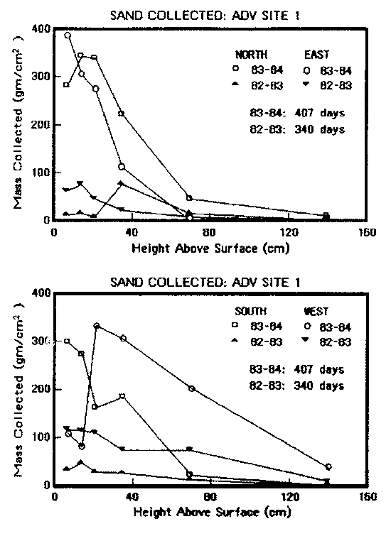
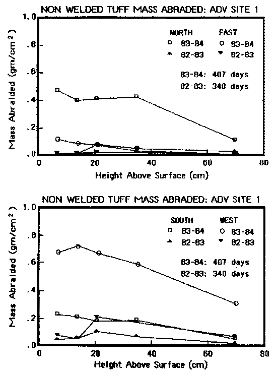
This year's results confirm this wide range in year-to-year variation: maximum annual abrasion determined from a 407 day exposure was approximately O. 05 millimeter for basalt, O. 10 millimeter for dolerite, and 3.70 millimeters for the nonwelded tuff. Figure 1a and Figure 1b shows the differences between the two year-long exposures in the amount of sand collected from each of four directions (as a function of height) and the similar differences in the amount of abrasion of the tuff. Note that the height scale (X-axis) is expanded by a factor of two for the abrasion target graphs. The lower amounts of sand collected near the surface reflect (1) the lower velocity of particles (they have greater difficulty getting into the sand traps), (2) self-interference between particles within the lower portion of the saltation curtain, and (3) some divergent aerodynamic pressure developed by the movement of air around and through the sand collectors and their support structure.
The values noted above are nearly a factor of 100 times lower than the rates determined by a laboratory wind-tunnel experiment (Miotke 1979, 1982). The conclusion that "ventifacts ... can be formed within a few decades or, at most, a few centuries" (Miotke 1979, 1982) is not supported; a longer interval (100 times or greater) is more likely, and is geologically more reasonable, given the age of debris distributed within the ice-free areas by past glaciations. However, two exceptions must be placed on interpretation of the results reported here. First, although the sand flux at site 1 is the highest available within the dry valleys, this does not mean that the abrasion is the greatest, because the very existence of the dunes argues that their locale is not subjected to winds of either sufficient magnitude or duration to export the sand. Second, preliminary inspection of samples recovered from other sites indicates that enhanced abrasion occurs in areas of coarser debris, where both the mass of the impacting particles and the wind speeds needed to move them are significantly greater than at the dunes. Although winds capable of transporting these particles are rare, considerable abrasion takes place when they do occur. I have a paper in preparation which will explore these exceptions.
Large ripples and waveforms in the Transantarctic Mountains
During the 1982 - 1983 austral summer, H. Borns (University of Maine) noted a large number of remarkable ripple forms during his field work in the Allan Hills. He suggested that these ripples, composed of pebbles and cobbles, might be wind-formed, although fluvial or subglacial origins were thought to be more likely. Denton et al. (1984) use fields of these ripples (which are seen throughout the Transantarctic Mountains and are interpreted to have been formed by subglacial sheet flow) to infer major ice-flow directions for ice-sheet episodes.During a brief visit to the Allan Hills at the end of the 1983-1984 season, I noted that the ripples have sufficient diversity of form and constituent materials to warrant a thorough investigation of the relative importance of wind in their formation, and more likely, modification. The specific interest for this project is the potential for transport of pebble-sized materials by the rare but strong winds noted by our dry-valley experiment.
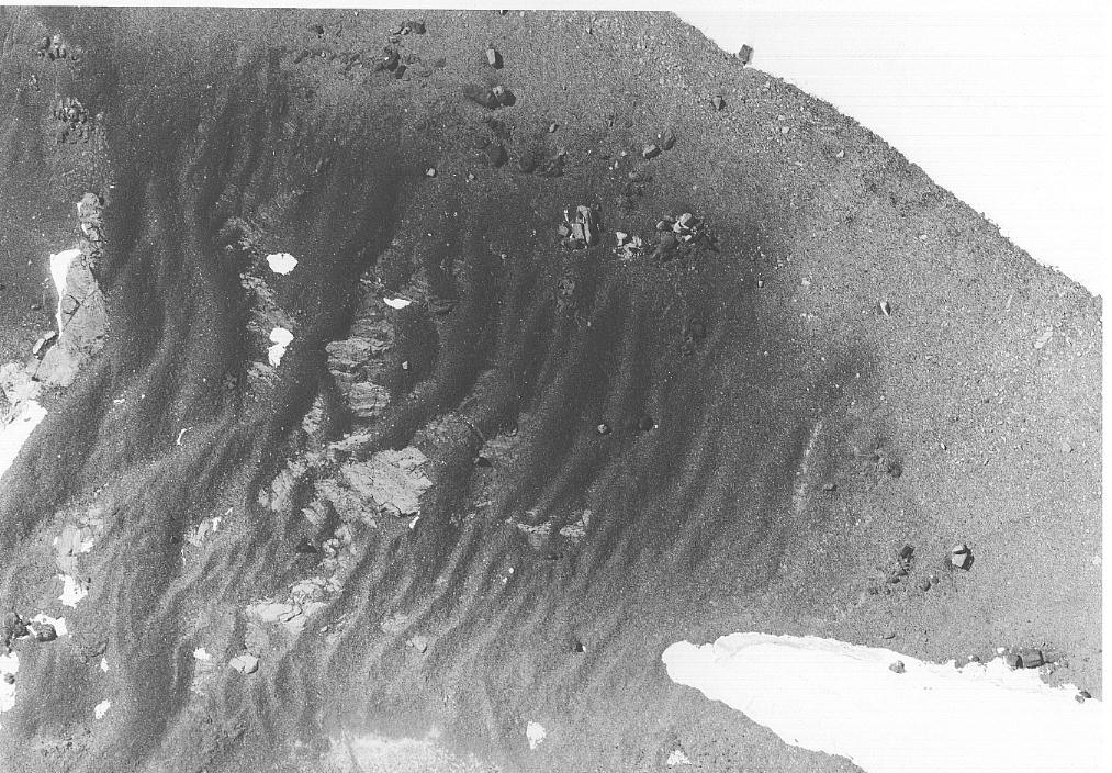
During the 1984-1985 season, I surveyed six ripple fields in a relatively small (about 2-kilometer square) area within the north central portion of the Allan Hills. Maximum ripple wavelength was in excess of 30 meters, with an amplitude more than 2 meters; most were much smaller. Figure 2 shows an aerial view of a portion of one field of ripples (Allan Hills ripple site 2A). The ripples in this figure are about 30 centimeters in amplitude and exist as isolated deposits resting on bedrock. In many places, the ripples form a continuous surface layer of variable thickness, although rarely in excess of 50 centimeters. Figure 3 shows the wavelength/amplitude relationship for representative fields of ripples in the Allan Hills and at two additional sites, one atop the Dais in upper Wright Valley and one within "Cirque 6" (as numbered eastward along the south wall of upper Wright Valley).
Many of the ripples appear to owe a significant portion of their wave
form to the underlying bedrock. Mostly the ripples are very thin
mantles of debris, and the largest amplitudes and wavelengths measured
are clearly those of the bedrock wave forms. At each site, a trench
was excavated, and the stratigraphy was measured and sampled. Some
ripples have well defined internal bedding, but for the most part such
features are absent. Sedimentological analyses of the ripple samples
are presently under way. Studies of sorting parameters, microscopic
examination of particle surfaces, and numerical models of sediment
transport capacity will be used in an attempt to decipher the
mechanisms by which the ripples evolved. Such studies may also help to
determine the relationships between the ripples and the ice-sheet
overriding episodes.
Malin, M. C. 1984. Preliminary abrasion rate observations in Victoria Valley,
Antarctica. Antarctic Journal of the U.S., 18(5), 25-26.
Malin, M. C. 1985. Abrasion rate observations in Victoria Valley, Antarctica:
340-day experiment. Antarctic Journal of the U.S., 19(5), 14-
16.
Miotke, E-D. 1979. Die formung und formungsgeschwindigkeit von Windkantern in
Victoria-Land, Antarktis. Polarforschung, 49(1), 30-43.
Miotke, E-D. 1982. Formation and rate of formation of ventifacts in Victoria
Land, Antarctica. Polar Geography and Geology, 6(2), 90-113.
(English translation of Miotke 1979.)
![]()
21 KBytes
GIF = 794 KBytes
JPEG = 185 KBytes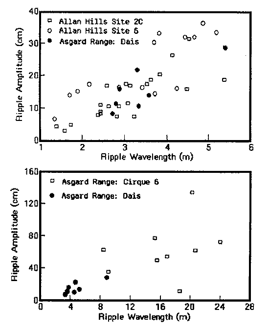
Figure 3: Ripple wavelength versus amplitude plot for
representative ripple fields in the Allan Hills and Asgard Range. The
Dais values ar plotted on both graphs for reference. ("m" denotes
"meter" "cm" denotes "centimeter")Acknowledgments
M. Malin and D. Janke conducted field work during austral summer
1984-1985, retrieving samples emplaced the previous season by Malin
and D. Eppler and surveying the Allan Hills ripple fields. Malin and
D. Lasorsa performed the half-day reconnaissance at the Allan Hills
during austral summer 1983-1984. D. Michna has been chiefly
responsible for the preparation of samples and the analysis of their
changes from the inception of the project. Without the expert support
of the helicopter pilots and crews of VXE-6, none of this research
would have been possible. I am especially indebted to Mort Turner for
his confidence in and support of this project. This work was supported
by National Science Foundation grant DPP 82-06391.References
Denton, G. H., M. L. Prentice, D. E. Kellogg, and T. B. Kellogg. 1984. Late
Tertiary history of the Antarctic ice sheet: Evidence from the Dry Valleys.
Geology, 12, 263-267.