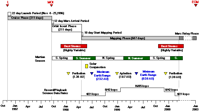
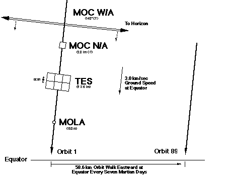
Mars Global Surveyor will utilize a sun-synchronous mapping orbit at a 378 km index altitude, and with a descending node orientation of 2:00 p.m. with respect to the fictitious mean Sun. In this 92.9&176 inclination orbit, the MGS spacecraft will circle the red planet once every 117.65 minutes. Once every seven Martian days (sols), the spacecraft will approximately retrace its ground track. After each seven sol cycle (88 orbits), the ground track pattern will be offset by 59 km eastward from the tracks on the previous cycle. If the orbit is perfectly maintained, then the entire network of ground track patterns will nearly repeat itself after a time span of about 26 sols (327 orbits), and almost exactly repeat after 550 sols (6917 orbits). Such a repeat cycle scheme will allow 99.9% global coverage to be built up from repeated instrument swaths across the planet.
Repetitive observations of the planet's surface and atmosphere from the mapping orbit will be conducted over a time span of one complete Martian year (687 Earth days). Throughout this entire period, the spacecraft remain in an orientation with the scientific instruments nadir pointed. Because MGS lacks a scan platform, any scanning capability will be provided by the instruments. The normal sequence of collecting science data will involve recording continuously for about 24 hours, and then playing it back through the Deep Space Network (DSN) during a 10-hour tracking pass once every day. Approximately every third day, an additional tracking pass will be scheduled to return high-rate, real-time data. Currently, primary mapping operations will occur between April 1998 and February 2000. From the end of mapping until the end of mission in January 2003, MGS is scheduled to support the Mars Surveyor Program by relaying data from various landers and atmospheric vehicles to the Earth.
Figure 2-1: General Timeline for MGS Mission
Event               Date                          Comments
Launch              4 Nov 1996                    Launch period opens on 4 Nov 1996
                                                  and closes on 25 Nov 1996
Inner Cruise Phase  4 Nov 1996 to 3 Jan 1997      Communications through LGA only
                                                  because solar arrays must be
                                                  pointed at a fixed angle to Sun
TCM1                19 Nov 1996  (L+ 15 days)     Trajectory correct for injection
                                                  errors
Outer Cruise Phase  3 Jan 1997 to 10 Sep 1997     Communications through HGA, phase
                                                  begins when Earth-MGS-Sun angle
                                                  falls below 60 degrees
TCM2                19 Mar 97 (TCM1+ 120 days)    Correct for execution errors from
                                                  TCM1
TCM3                18 Apr 97 (TCM2+ 30 days)     Correct for execution errors from
                                                  TCM2
TCM4                22 Aug 1997 (MOI- 20 days)    Final adjustment to MOI aim point
Mars Orbit          11 Sep 1997                   MOI can vary from 11 Sep 97 to 22
Insertion (MOI)                                   Sep 97 depending on exact launch
                                                  date
Orbit Insertion     11 Sep 1997 to 5 Apr 1998     begins at MOI, and lasts about 5
Phase                                             months to reach mapping orbit
                                                  using aerobrake maneuvers
Mapping Phase       9 Apr 1998 to 25 Feb 2000     Mars mapping operations for one
                                                  Martian year, about 687 days.
                                                  Launch at end of launch period
                                                  will push start of mapping back to
                                                  18 April 1998
Relay Phase         22 Feb 2000 to 1 Jan 2003     About 3 Earth years
Inner Cruise Sub-phase
Inner cruise extends from PAM-D separation until sometime in January 1997, defined by the time period when communications with the Earth occurs though the low gain antenna (LGA). The reason is primarily due to the spacecraft configuration and solar panel geometry. Because the high gain antenna (HGA) sits on the spacecraft in a stowed, body-fixed orientation during cruise, communicating with the Earth through the HGA will require turning the spacecraft to point the antenna directly at Earth. However, such an orientation would push the incidence angle of sunlight on the panels past acceptable levels for minimum power generation. Therefore, communications through the LGA represents the only feasible option.
During inner cruise, initial deployment and checkout of the spacecraft and payload will be accomplished, and navigation tracking data will be taken to determine the flight path for the purpose of planning and executing the first of four planned trajectory correction maneuvers (TCMs). TCM1 always occurs 15 days after launch (L+ 15 days).
Outer Cruise Sub-phase
Technically, outer cruise will begin when the spacecraft switches from use of the low gain to the high gain antenna for communications with the Earth. The exact time when the switch becomes feasible depends on when the angle between the Sun and Earth as seen from the spacecraft (SPE) falls to a level low enough to allow good power while the spacecraft is oriented to point the HGA directly at Earth. This angle starts at about 120° at the time of launch and falls to less than 60° by February 1997.
Currently, the transition date to switch to the HGA from has not yet been determined to a greater fidelity than sometime during January 1997, and no later than 1 February 1997. Once the date has been identified, it will still be subject to change during flight as the spacecraft team evaluates the telemetry. In the interest of maintaining the highest possible communications link margin with Earth, switch over will occur as early as possible.
Most of this sub-phase consists of minimal activity as the spacecraft transits to Mars. The vast majority of the significant events will involve acquiring navigation and tracking data to support the remaining TCMs. During the last 30 days of approach to Mars, the focus will be on final targeting of the spacecraft to the proper aim point, and preparations for orbit insertion.
Mars Capture Sub-phase
The Mars capture sub-phase extends from MOI burn ignition and ends at the beginning of the first aerobrake walk-in maneuver (AB1). This burn will lower periapsis to an altitude of 138 kilometers and correct for slight inclination errors incurred during the orbit insertion burn. Currently, AB1 is scheduled to occur at the fourth apoapsis passage after MOI. Under normal circumstances, MOI will place the MGS spacecraft into a highly elliptical, 48 hour period capture orbit at a descending node orientation of approximately 5:45 p.m. Therefore, AB1 will nominally occur nine days after MOI.
Aerobrake Sub-phase
Aerobraking consists of three distinct sub-phases: walk-in, main phase, and walk-out. Walk-in represents the first of the three to occur and begins about nine days after MOI with the AB1 maneuver that lowers periapsis from the capture orbit periapsis altitude of 300 kilometers to 138 kilometers. Over the next month, three more walk in maneuvers (AB2, AB3, and AB4) will gradually lower the periapsis to 112 kilometers and reduce the period to about 40.6 hours.
After the completion of walk-in, the spacecraft will spend three months in the main phase of aerobraking. During this period of time, repeated periapsis passages through the upper fringes of the Martian atmosphere will gradually slow the spacecraft and lower the apoapsis. By the end of the aerobrake main phase, atmospheric drag will have lowered the apoapsis from the original altitude of 57,000 kilometers down to about 2,000 kilometers.
The three weeks of aerobraking following the main phase represent an extremely critical period as the spacecraft lowers its apoapsis down to 450 kilometers. During that time, the MGS spacecraft will slowly "walk-out" of the atmosphere by gradually raising its periapsis altitude to 143 kilometers. Daily aerobraking trim maneuvers (ABMs) will be performed as necessary to maintain a three day orbit lifetime. In other words, in the absence of ABMs due to unforeseen events that inhibit the ability of flight controllers to command the spacecraft, MGS will always be at least three days from a fiery crash.
Aerobraking will end with a termination burn (ABX) performed in late January 1998. This burn will raise the orbit periapsis out of the atmosphere, and to an altitude of approximately 400 kilometers. At this time, the spacecraft will be circling in a 400 x 450 kilometer orbit with a period slightly under two hours. In addition, the descending node location will have advanced from its original MOI position at 5:45 p.m. with respect to the fictitious mean Sun to nearly 2:00 p.m.
Transition-to-Mapping Sub-phase
Transition-to-mapping begins at the end of aerobraking and lasts until the final mapping orbit has been established and the spacecraft is declared ready to begin mapping operations. After the aerobrake termination burn (ABX), the spacecraft will circle Mars in a "trans-map" transition orbit for about 25 days. During this waiting period, the oblateness of Mars will alter the orbit and cause the location of periapsis to drift to a position almost immediately above the Martian south pole. At that time, the transition to mapping orbit (TMO) burn will be performed with the intent of "freezing" the periapsis location at the south pole, and establishing the proper altitude for mapping operations. Currently, TMO will occur sometime during mid-February 1998.
After the TMO burn, about one month will elapse before mapping operations begin. In this month, the navigation team will conduct gravity calibrations for seven days to ensure that the MGS spacecraft has reached the proper mapping orbit, and to update the Martian gravity field model using in-flight navigation data returned from the red planet. If necessary, an orbit trim maneuver (OTM) burn will be executed to refine the frozen orbit based on the results of the gravity calibration. Next, a ten day period spacecraft deployment and checkout period will follow the OTM to allow the operations team to configurethe spacecraft and its instruments for mapping operations
Throughout the course of mapping, the spacecraft will circle Mars every 117.65 minutes with an aerocentric periapsis altitude 354 kilometers over the southern polar region, and an apoapsis altitude of 409 kilometers over the northern region. In addition, the mapping orbit will be "frozen" to keep the apsidal locations from drifting away from the poles, and to keep the altitudes constant at an index value of 378 kilometers (eccentricity value about 0.007).
During normal mapping operations, the scientific instruments will always remain nadir pointed, and will collect data on a continuous basis. Solid state recording devices on the MGS spacecraft will record this data for later transmission to Earth. Current plans call for 24 hours of recorded science data to be returned once per Earth day during a single 10 hour tracking pass at on the three DSN station locations.
Before relay operations begin, a quarantine orbit raise maneuver will elevate the spacecraft to a near-circular orbit with an average altitude of 405 kilometers. This quarantine orbit is needed to reduce the probabilities of spacecraft impact with Mars before L+ 20 years and L+ 50 years to the values required for planetary protection.
In general, maneuvers for this mission fall into two different categories. The first, called bi-propellant maneuvers, represents the larger of the two, will utilize the spacecraft's main engine, and will burn a combination of hydrazine and nitrogen tetroxide. The second type, called mono-propellant maneuvers, will employ the much smaller attitude control thrusters and will use only hydrazine. During bi-propellant maneuvers, the main engine will provide translational Delta-V and the smaller thrusters will provide attitude control (rotational Delta-V) in mono-propellant mode. For the smaller sized mono-propellant maneuvers, the attitude control thrusters will provide the translational Delta-V.
The next table shows the DV allocation for each maneuver in the MGS mission. "Trans." stands for translational, and "Rotat." stands for rotational. All velocities are expressed in meters per second.
Mission Phase       Maneuver Name /     Trans.    Rotat.      Comments
                    (Type)              Delta-V   Delta-V

Cruise              TCM 1 and 2 (bi)    54.7 3.0    0.3       Values based on 95%
                    TCM 3 and 4 (mono)                        statistical confidence
                                                              level
Orbit Insertion     MOI (bi)            977.1       5.9       Pitch-over burn,
                                                              Delta-V includes
                                                              finite burn loses, Rp
                                                              = 3700 km
Aerobrake Walk-in   AB1 (bi) AB2        10.0        0.1       1.5 m/s reserved for
                    (mono) AB3 (mono)   1.5 0.5               Delta-i Periapsis =
                    AB4 (mono)          0.5                   118 km Periapsis = 113
                                                              km Periapsis = 112 km
Aerobrake Main      ABM (mono)          4.0         5.0       Aerobrake corridor
Phase                                                         control burns
Aerobrake Walk-out  ABM (mono)          21.0        25.0      Used to slowly raise
                                                              periapsis
Transition to       ABX (bi) TMO (bi)   57.0        0.3 0.1   Raise periapsis to
Mapping             Contingency (bi /   18.0                  about 400 km Establish
                    mono)               14.7 /                mapping orbit
                                        8.5                   Aerobrake emergencies
Mapping             OTM drag (bi /      7.0 /        46.5     OTMs used primarily
                    mono)  ACS          3.9                   for drag make-up, ACS
                    Rotation (mono)                           for momentum wheel
                                                              unloading
Quarantine Raise    PQ (mono)           12.0                  Performed at end of
                                                              mapping
Relay               OTM drag (bi /      4.8          8.5      OTMs used primarily
                    mono) ACS                                 for drag make-up, ACS
                    Rotation (mono)                           for momentum wheel
                                                              unloading
                    Sub-Total (bi /     1138 /       91.8     Grand total Delta-V
                    mono) Sub-Total     60                    for entire MGS mission
                    (mono)                                    is 1290 m/s
b) Determine the composition, map the distribution, and measure the surface thermo-physical properties of surface minerals, rocks, and ices.
c) Determine globally the topography, geodetic figure, and gravitational field.
d) Establish the nature of the magnetic field and map the crustal remnant field.
e) Monitor global weather and thermal structure of the atmosphere.
f) Study surface-atmosphere interaction by monitoring surface features, polar caps, polar thermal balance, atmospheric dust, and clouds over a seasonal cycle.
g) Provide multiple years of on-orbit relay communications capability for Mars landers and atmospheric vehicles from any nation interested in participating in the International Mars Surveyor Program.
h) Support planning for future Mars missions through data acquisitions with special emphasis on those measurements which could impact landing site selection.
Acronym       Full Name           Lead Center                Measurement Objective

MAG / ER      Magnetometer /      Goddard Space Flight       Intrinsic magnetic field
              Electron            Center (GSFC)              and solar wind
              Reflectometer                                  interaction with Mars

MOC           Mars Orbiter        Malin Space Science        Surface and atmospheric
              Camera              Systems (MSSS)             imaging

MOLA          Mars Orbiter        Goddard Space Flight       Surface topography
              Laser Altimeter     Center  (GSFC)

MR            Mars Relay          France (CNES)              Support for future Mars
                                                             missions, American and
                                                             international

TES           Thermal Emissions   Arizona State University   Gravity field and
              Spectrometer        (ASU)                      atmospheric refractivity
                                                             profiles

USO           Ultra Stable        Stanford University        Mineralogy, condensates,
              Oscillator for      (team leader)              dust, thermal
              Radio Science                                  properties, and
                                                             atmospheric measurements
Depending on the ground track spacing and the amount of collected data, the Magnetometer can identify surface magnetic features of sufficient strength with a spatial resolution roughly equal to the orbit altitude. With careful calibration, the MGS spacecraft's contribution to the magnetic field can be subtracted from this data.
Figure 2-2: Footprints of MGS Instruments
The Electron Reflectometer will provide a gain of 10 to 100 in sensitivity and a gain in spatial resolution of about three times as compared to direct magnetic mapping for near-surface magnetic features. In order to determine the location of the magnetic field being sampled and the field strength of the absorbing layer in the atmosphere, the ER will require the independent measurement of the magnetic field.
The MOC's two wide-angle optical assemblies use 140° field-of-view "fisheye" lenses to see from horizon to horizon. These two cameras employ red (575-625 nanometers) and blue (400-450 nanometers) filters for color imaging, and their resolution varies from about 300 meters per pixel at the nadir to roughly two kilometers at the limb. Together, they function in two of the MOC's three data collection modes. The first mode, called global monitoring mode, will provide daily, full-planet observations of the atmosphere and surface to document changes over time. In contrast, the regional monitoring mode will observe selected atmospheric phenomena and surface features at resolutions as high as 300 meters per pixel.
In the third mode, called high resolution mode, the narrow-angle optics will sample important areas of the planet in great detail. The narrow-angle optical assembly will use a Ritchey-Chretien telescope to acquire images about 2.8 km across at a resolution of about 1.4 meters per pixel. Simultaneous wide-angle images will provide positional and meteorological context for the narrow-angle frames.
Figure 2-3: Mars Orbiter Camera (MOC)
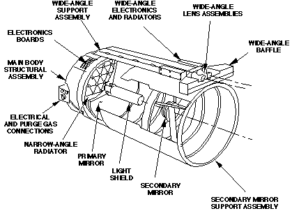
MOC's electronics include a 12 megabyte buffer for data and sequence storage, and a 32-bit microprocessor to accommodate sophisticated software for acquiring, processing, and compressing the images. Average data rates for the instrument will vary from 700 bps to over 40 kbps, depending on the available downlink rate.
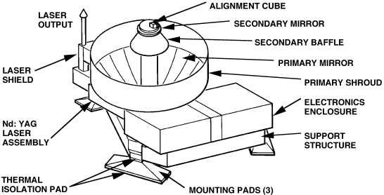
MOLA consists primarily of a pulsed laser ranging system firing 10 pulses per second. The laser transmitter will utilize a diode-pumped Nd-YAG (Neodymium-Yttrium Aluminum Garnet) laser with a 1.06 µ m wavelength operating at an output power of 45 mJ per pulse. The receiving optics, a Cassegrain telescope with a 50-cm primary mirror, will focuses the return signal on a silicon avalanche photodiode detector.
Each laser spot will measure about 160 meters on the surface with a spacing of about 300 meters (0.1 second) per spot. The accuracy in measuring relative topography will vary from one to ten meters, with an absolute accuracy of about 30 meters. However, the absolute accuracy will ultimately depend on precise reconstruction of the spacecraft orbital position from the radio science gravity field results. MOLA will operate at a single data rate of 618 bps.
Figure 2-4: Mars Orbiter Laser Altimeter (MOLA)
MR consists of a 1-meter helix antenna mounted on the nadir panel and all of the associated electronics. Unlike the main X-band telecommunications sub-system, this device operates at UHF frequencies near 400 MHz. The antenna pattern (-3 dB) takes the form of a 65° cone emanating from the tip of the antenna, and provides coverage to the horizon with a 4,700 km effective range for a 8 kbps data rate. However, the range drops to about 1,200 km for the 128 kbps data rate.
As the spacecraft orbits the red planet in relay mode, the MR will transmit a simple electronic beacon to the surface indicating to lander stations that the MGS spacecraft is approximately "overhead." This beacon will serve as an indicator for the ground stations to begin transmitting their data. At this time, detailed plans have not yet been formulated for the return of data from the various lander and atmospheric vehicles. Currently, the project is working out scenarios for possibly using the MR to facilitate the return of data from the landers of the Russian Mars 96 mission.
Second, radio Doppler tracking of the spacecraft will provide improved information on the structure of the Martian gravitational field through measurement of its effect on the spacecraft's motion. The low altitude polar orbit, plus improvements in the spacecraft telecommunication subsystem (X-band uplink and downlink), will yield unprecedented spatial resolution, global coverage, and accuracy of the derived gravitational field model. This data will permit parameter estimation of Mars' internal structure and inferences of the red planet's geological evolution.
Unlike any other Mars Global Surveyor experiment team, the Radio Science Team does not rely on a specific scientific instrument. Instead, the spacecraft telecommunications subsystem, augmented by an ultra-stable oscillator, will operate together with one of several ground tracking stations of the DSN. Essentially, raw data will be acquired at the DSN station and then delivered to investigators via the Project Data Base.
Figure 2-5: Thermal Emission Spectrometer (TES)
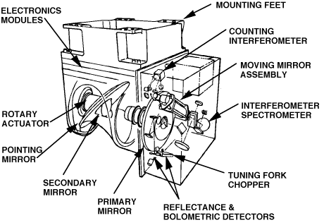
TES will function as a combined infrared spectrometer and radiometer designed to measure energy from the surface and atmosphere of Mars in the spectral range of 0.3 to 100 µ m. This instrument primarily consists of two nadir-pointing telescopes that share a common pointing mirror system. The larger of the two telescopes is a 15.24 cm diameter Cassegrain afocal design that feeds a two-port Michelson interferometer spectrometer with a spectral range from 6.25 to 50 µ m. The smaller of the two serves two bolometric channels (0.3 to 3.9 µ m and 0.3 to 100 µ m), measures only 1.5 cm in diameter, and takes the from of an off-axis paraboloidal telescope boresighted with the larger telescope.
Each telescope utilizes six detectors, each with an 8.3 by 8.3 mrad field of view. The six form a rectangular grid three frames wide in the cross-track direction, and two frames wide down-track. By employing a rotating scan mirror, TES will be able to view Mars from horizon to horizon (forward and backward along the ground track) despite the fact that the spacecraft will always remain nadir pointed. On the average, TES will operate at either 688, 1,664, or 4,992 bps.
Figure 2-6: View of MGS Spacecraft
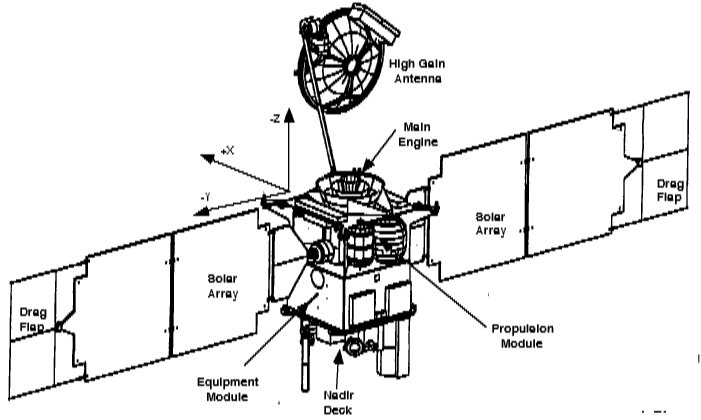
When fully loaded with hydrazine at the time of launch, the spacecraft will weigh no more than 1,052 kilograms under the current design and Delta-V budget. In order to meet this target mass, the spacecraft structure will consist of lightweight composite material divided into four sub-assemblies known as the equipment module, the propulsion module, the solar array support structure, and the high gain antenna support structure.
For the most part, the equipment module's main function involves housing the avionics packages and science instruments. The dimensions of this rectangular shaped module measure 1.221 x 1.221 x 0.762 meters in the X, Y, and Z directions, respectively. With the exception of the Magnetometer, all of the science instruments will bolted to the nadir equipment deck, mounted above the equipment module on the +Z panel. The Mars Relay (MR) is the tallest instrument and sticks up 1.115 meters above the nadir equipment deck.
The propulsion module serves as the adapter between the launch vehicle and contains the propellant tanks, main engines, and attitude control thrusters. This module bolts beneath the equipment module on the -Z panel. Essentially, the module consists of rectangular shaped box 1.063 meters on each side, with a .310 meter tall cylindrical shaped launch vehicle adapter sticking out from the bottom of the box. Each corner of the box portion of the module contains a small metal protrusion that houses attitude control thrusters. Including the length of these protrusions, the diagonal widths of the propulsion module measure 2.464 and 2.394 meters long.
Two solar arrays, each 3.531 meters long by 1.854 meters wide will provide power for the MGS spacecraft. Each array mounts close to the top of the propulsion module on the +Y and -Y panels, near the interface between the propulsion and equipment modules. Including the adapter that holds the array to the propulsion module, the tips of the arrays stick out 4.270 meters from the sides of the spacecraft. Rectangular shaped, metal drag "flaps" mounted onto the ends of both arrays add another .813 meters to the overall array structure. These "flaps" serve no purpose other than to increase the total surface area of the array structure to increase the spacecraft's ballistic coefficient during aerobraking. The two Magnetometer sensors mount on the end of each solar array, in between the array and the flap.
In addition to the solar arrays, the high gain antenna (HGA) structure also bolts to the outside of the propulsion module. When fully deployed, the 1.5 meter diameter HGA will sit at the end of a 2.0 meter long boom, mounted to the +X panel of the propulsion module.
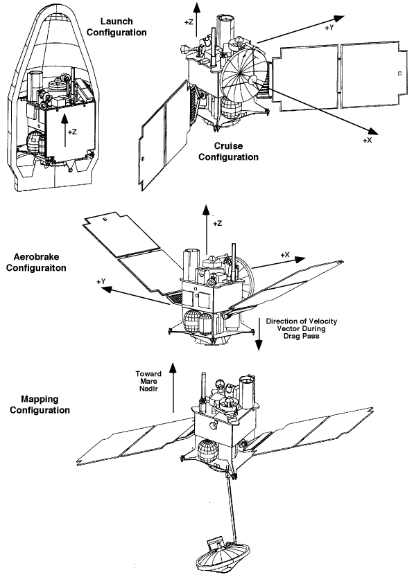
Launch Configuration
Although the solar panels and HGA attach to the propulsion module, they will be initially stowed and folded upward against the rectangular equipment module at the time of launch. When attached to the Delta rocket, the XY plane of the spacecraft will lie perpendicular to the longitudinal axis of the Delta. Since the instruments will be pointed in the spacecraft's +Z direction, they will point upward along the Delta's longitudinal axis, toward the top of the booster's payload fairing during flight.
Shortly after the Delta jettisons its first stage, it will also jettison the payload fairing and expose the MGS spacecraft to the ambient environment. Because one of the mission flight rules dictates that the +Z axis (science instruments) can never be pointed within 30° of the Sun under nominal conditions, the Delta must fly an ascent trajectory that keeps its longitudinal axis at least 30° from the Sun.
DSN Initial Acquisition
After completion of the trans-Mars injection burn by the Delta's third stage, the spacecraft will be de-spun from the upper stage's spin stabilized rate of 60 r.p.m. before separating from the stage. At this time, the spacecraft will not know its inertial attitude because the third stage's spin rate is sufficiently high to saturate the gyroscopes in the spacecraft's inertial measurement units (IMUs). The only course of action will involve using the sun sensors to point the spacecraft's +X axis directly at the Sun.
In this attitude, the undeployed HGA will pointed directly at the Sun, and the solar arrays will be swept forward toward the Sun, 30o above the Y axis in the +X direction. The spacecraft will then hold this attitude for two hours to allow for initial acquisition from the tracking antennas of the Deep Space Network (DSN). Since the HGA will point at the Sun during in this mode, initial acquisition must occur on the low gain antenna (LGA). Throughout this time period, the spacecraft will spin at the rate of one revolution every 100 minutes about its +X axis.
Inner Cruise Sun Coning
This next configuration mode will allow the spacecraft to initialize its star catalog after completing DSN initial acquisition. This initialization must be performed to give the spacecraft a fixed "reference" point from which to determine attitude. Without it, the spacecraft will not be able to assume any arbitrary attitude other than those derived from the vector to the Sun.
During inner cruise sun coning, the solar arrays will be swept forward 30° above the Y axis in the +X direction, exactly the same as in the DSN initial acquisition configuration. However, the undeployed HGA on the +X axis will always point somewhere along the edge of an imaginary cone with a half-angle of 60° and longitudinal axis along the vector to the Sun. In this orientation, the spacecraft will spin so that its +X axis traces a path around this 120° Sun exclusion cone once every 100 minutes. Therefore, the spacecraft +X axis is said to be "coning 60° off the Sun." This coning motion will last for at least 200 minutes to allow the star sensors (CSA) enough time to initialize the catalog.
Inner Cruise Array Normal Spin (ANS)
After initializing the star catalog, the spacecraft will transition to inner cruise array normal spin (ANS). In this orientation, the solar arrays will lie in the same position relative to the spacecraft body (30° swept forward toward +X axis) as during inner cruise sun coning. However, the difference is that the +X axis will point to a position halfway between the Earth and Sun, and the spacecraft will roll at a rate of one revolution every 100 minutes around the +X axis.
Spinning halfway between the Earth and Sun represents a compromise between needing to point the +X axis directly at the Earth for maximum communications link margin, and needing to point the solar arrays at the Sun for adequate power generation. Communications with the Earth will always occur through the low gain antenna during inner cruise ANS because the undeployed HGA on the +X axis must point directly at the Earth for use.
Figure 2-7: MGS Spacecraft Configurations (flaps not shown)
Outer Cruise Array Normal Spin (ANS)
About two months after launch and sometime in January 1997, the angle between the Earth and Sun as seen from the spacecraft will allow for pointing the undeployed HGA directly at Earth and still provide for adequate illumination of the solar arrays. From this time until Mars orbit insertion, excluding trajectory correction maneuvers, the nominal spacecraft configuration will be outer cruise array normal spin in order to take advantage of the decreasing angles between the Earth and Sun. When configured in this mode, the spacecraft solar panels will lie swept forward 30° above the Y axis toward the +X direction, +X axis of the spacecraft will point directly at the Earth, and the spacecraft will roll about the +X axis one revolution every 100 minutes.
In the inner cruise Sun coning, inner cruise array normal spin, and outer cruise array normal spin, the solar arrays will lie in the same orientation, and the spacecraft will turn at the same rate of 0.01 revolutions per minute. The only difference is whether the spacecraft spins or cones, and the location of the primary axis of revolution.
Maneuver Configuration
Executing maneuver burns will require a different configuration from the previous three modes discussed. All of the large maneuvers will use the main engine, located on the bottom (-Z panel) of the propulsion module. During the burns, the solar panels will be swept back 30° below the Y axis, toward the - Z direction. The reason for this choice is that the thrust direction of the main engine lies along the -Z axis. By sweeping the panels in that direction , as opposed to the +X direction, the spacecraft center of mass will be better aligned with the main engine's thrust axis. In all cases, the active side of the solar panels will also point in the -Z direction.
The spacecraft will use the maneuver configuration for all four trajectory correction maneuvers (TCMs) and Mars orbit insertion (MOI). In addition, this configuration will also be used for all major orbit change maneuvers at Mars such as OTMs, TMO, and ABx burns whether or not the burn is performed with the main engine or attitude control system.
Aerobrake Nominal Configuration
The nominal spacecraft configuration during aerobrake drag passes will resemble the maneuver configuration, except the solar panels will point in the opposite direction. In this case, the panels will be swept 30° above the Y axis, toward the +Z direction, and the active side of the solar array will point in the +Z instead of the -Z direction. Because the spacecraft will fly through the drag pass -Z axis (main engine end) forward during the drag pass, this orientation will maximize protection for the arrays by keeping their active side away from the oncoming airflow. In addition, the +X axis will remain nadir pointed throughout the duration of an aerobrake drag pass.
For all propulsive maneuvers and for the aerobraking drag passes, the spacecraft will turn under 3- axis control to the maneuver attitude. Then, upon completion of the maneuver, the spacecraft will return to the attitude and configuration required for the current mission phase.
Mapping Configuration
After insertion into the mapping orbit after the aerobrake phase of the mission, the MGS spacecraft will be configured for mapping operations. In this mode, the spacecraft will be 3-axis controlled, using input from the horizon sensors to maintain the science instruments on the +Z panel pointed in the nadir direction. Also, the +X side of the spacecraft will point forward in the direction of orbital motion, and the spacecraft will complete one revolution about the Y axis once per orbit.
Because the mapping orbit is Sun-synchronous with respect to 2:00 p.m. of the fictitious mean Sun, the Sun will always shine (except during eclipse periods) on the +Y spacecraft side at an angle that varies between 50° and 74° from the +Y axis (or 16° to 40° from +X), depending on the Martian time of year. The solar arrays gimbal drive control will be enabled to automatically track the Sun as the spacecraft progresses around the orbit. In addition, the HGA boom will be deployed and its gimbal drive control will allow the antenna to track the Earth around each orbit. This configuration will allow the HGA to point directly at Earth without rotating the entire spacecraft.
b) Controls interface unit (CIU) that connects the computers to other spacecraft components.
c) Engineering data formatter (EDF) that formats engineering telemetry.
d) Payload data subsystem (PDS) that provides the command and data interface to the science instruments.
e) Cross-strap unit (XSU) that routes telemetry to the solid-state flight recorders and to the telecommunications sub-system.
f) Two solid state recorders (SSR) units that record science and engineering telemetry, each with a 1,500 Mbit storage capacity.
General Description of Anomaly Modes
Fault protection will automatically transition the spacecraft into a safe, neutral attitude and configuration in the event of an in-flight anomaly. The purpose is to keep the spacecraft from further executing functions that could lead to hardware damage or loss of mission, and to provide ground control an opportunity to recover from the anomaly.
Three basic fault protection modes exist. Emergency mode is the least serious level of emergency response and will assist the spacecraft in times of communications difficulties, especially in the event of a command-loss timeout. Contingency mode represents a more extreme response than emergency mode and is designed to combat anomalies in telecommunications, power, or attitude control. Safe mode is the most serious of the three and places the spacecraft into what can qualitatively be described as a "minimal effort survival mode." Essentially, safe mode will provide a final fallback mode of reduced operations in the event of major sub-system problems, or loss or corruption of the RAM code. As such, safe mode software is located in the SCP PROM. Entry into safe mode will occur if a key spacecraft component fails or if the flight computers encounter a power-on-reset condition.
Data Rates
The C&DH sub-system will handle three different types data streams of science data, engineering data, or a combination of both.
(b) Science and Engineering 2 (S&E-2), a combined science and engineering data stream for returning high-rate science in real-time only.
(c) Engineering (ENG), an engineering only data stream that can be recorded for later playback, returned in real-time, or both.
Data Stream      Record Rate      Playback Rate      Real-time Rate
S&E-1            4000 sps         21333.333 sps      4000 sps
                 8000 sps         42666.667 sps      8000 sps
                 16000 sps        85333.333 sps      16000 sps
S&E-2            n/a              n/a                40000 sps
                 n/a              n/a                80000 sps
ENG              2000 bps         8000 bps           2000 bps
                 n/a              n/a                250 bps
                 n/a              n/a                10 bps
Notice that in S&E1, playback of recorded data always occurs at a rate 5.333 times faster than the record rate. This ratio will allow the spacecraft to return 24 hours of recorded data during a single 10 hour DSN tracking pass. In addition, the 80,000 sps real-time S&E2 is a capability, but not an official project requirement. It will be implemented on a "best-effort" basis only.
The spacecraft will carry two solid state recorders (SSR) for redundancy. Each SSR contains two 0.75 Gbit recorders that support simultaneous record and playback. Therefore, each SSR can store up to 104 hours of data at the 4,000 sps record rate, and over 26 hours at the 16,000 sps record rate.
Bit allocations for each science instrument will vary depending on the data stream mode, and the specific data rate. Detailed information regarding these allocations can be found in Appendix ??.
Four different types of sensors will provide attitude information. The Sun sensors located in multiple locations on the spacecraft are the simplest and will provide extremely basic attitude knowledge, namely the location of the Sun. They will come into use for attitude acquisition after separation from the upper stage of the Delta, and to begin attitude re-initialization in the event of an anomaly.
Sensor type number two, the Inertial Measurement Unit (IMU), contains gyroscopes and accelerometers that will measure angular rates and linear accelerations. These measurements will be used to determine yaw attitude in the mapping phase. In addition, the IMU measurements will also aid the spacecraft in pointing inertially, for both fixed pointing and attitude slews during maneuvers.
Like the IMUs, the Mars Horizon Sensor Assembly (MHSA) will also provide key attitude data during the mapping phase. This device will primarily look at the atmospheric horizon to define the nadir direction by sensing roll and pitch errors.
Finally, the Celestial Sensor Assembly (CSA) will complement the IMUs by also providing inertial attitude data. The CSA works by scanning the position of distant stars, and will provide attitude control and knowledge during cruise, orbit insertion, and when precise knowledge is required during mapping. Both the MHSA and CSA mount to the +Z panel of the equipment module, next to the science instruments.
To achieve the required lifetime, the battery depth of discharge in the mapping orbit cannot normally exceed 27%. This limits the amount of time the spacecraft can transmit during eclipse. The spacecraft is required to support up to ten minutes of transmission in eclipse for the radio science occultation experiment.
During periods of "normal" operation in cruise, mapping, and relay phase, the project's requirement for DSN support are modest at one 10 hour track per day. However, critical operation such as launch, maneuvers (TCMs and MOI), and aerobraking operations will require continuous coverage. In addition, the project will also require continuous coverage for special, week-long science campaigns during mapping to take advantage of special orbit geometry conditions or to observe unique seasonal changes on Mars. The following table lists the MGS project's requirements for DSN tracking coverage.
The following table provides a profile of the tracking support required by the Mars Global Surveyor Project. Stations other than, but equivalent to a 34m HEF, such as a 34m BWG or 70m with comparable up and downlink performance, may only be substituted with negotiation from the project.
Time Period              Antenna     Tracking Coverage        Data Types
                                     Required

Launch to L+ 30 days     34m HEF     Continuous               2-way coherent Doppler
(includes TCM1 at L+                                          and ranging, angular
15 days)                                                      data from launch to L+
                                                              1 day, acquire
                                                              tracking data as soon
                                                              as possible after
                                                              launch

L+ 30 days to MOI- 90    34m HEF     10 hours/pass 1          2-way coherent
days (except for TCM2,               pass/day                 Doppler, 3-way Doppler
TCM3)                                                         and ranging

TCM2 (TCM1+ 120 days)    34m HEF     Continuous for a         2-way coherent Doppler
TCM3 (TCM2+ 30 days)                 period of 3 days         and ranging
                                     before TCM to 3 days
                                     after TCM

MOI- 90 days to MOI-     34m HEF     10 hours/pass 2          2-way coherent Doppler
30 days                              pass/day                 and ranging

MOI- 30 days to start    34m HEF     Continuous               2-way coherent
of mapping (includes                                          Doppler, 3-way Doppler
TCM4 at MOI- 20 days)                                         and ranging

MOI- 24 hours to MOI+    70m         Continuous               2-way coherent Doppler
24 hours                                                      and ranging

Routine Mapping          34m HEF     10 hours/pass 1          2-way coherent Doppler
Operations (about                    pass/day plus 1          and ranging, 3-way
5-Apr-98 to 21-Feb-00)               additional pass every    Doppler and ranging,
(see notes after this                3rd day for real time    open loop recording
table)                               data                     during atmospheric
                                                              occultations

Science Campaigns        34m HEF     Continuous for 88        Same as during routine
A: 2-Mar-98 to 9-Mar-98              orbits (approximately    mapping
B: 29-Jun-98 to 6-Jul-98             7.2 days)
C: 26-Oct-98 to 2-Nov-98
D1:5-Jan-99 to 12-Jan-99
D2:20-Jan-99 to 27-Jan-99
D3:3-Feb-99 to 10-Feb-99
D4:18-Feb-99 to 25-Feb-99
E: 3-May-99 to 10-May-99
F: 27-Sep-99 to 4-Oct-99
G:13-Dec-99 to 20-Dec-99
(see notes after this
table)

Diametric Occultations   34m HEF     10 hour/pass 2           During the overlap
Edge-on Orbital                      pass/day (w/ 2 hour      period, simultaneous
Configuration (28 day                overlap) 28-Oct-98 and   2-way coherent Doppler
duration centered on                 19-Feb-99 require        and 3-way Doppler.
dates of 28-Oct-98,                  continuous coverage      Otherwise, same as
19-Feb-99)                                                    during routine mapping
                                                              operations

Communications Relay     34m HEF     10 hours/pass 1          2-way coherent Doppler
Phase (22-Feb-00 to                  pass/day                 and ranging
1-Jan-03)
 Return to MSSS
Home Page
Return to MSSS
Home Page