Mars Global Surveyor
|
(A) MOC2-1612-a
Annotated Image — No Annotation |
(B) MOC2-1612-b
Annotated Image |
(C) MOC2-1612-c
Annotated Image |
(D) MOC2-1612-d
Annotated Map |
(E) MOC2-1612-e
Annotated Image — No Annotation |
Having realized that a new dark spot on Mars, seen in a red wide angle camera image acquired on 6 January 2006, might be an indication of a recent meteor impact site (see “How We Found the First of the Fresh Impact Sites that Formed During the Mars Global Surveyor Mission”), the Mars Global Surveyor (MGS) Mars Orbiter Camera (MOC) science operations team considered it possible to find more such impact sites using the MOC red wide angle camera. The most recent, freshest craters would be expected to be quite small, ranging from a few meters across to maybe a few hundred meters or so, at most, in diameter (100 meters is about 109 yards; compare that with a 100 yard U.S.-style football field). Something less than 100 meters across would not show up easily in a 240 meters per pixel red wide angle image. But the 6 January 2006 image showed that it could, because these small impacts, if they occur in an area thickly mantled with dust, will create a much larger “blast zone” around them.
Thus, the MOC science operations team set out to image a few of the dustiest regions on Mars—Tharsis, Amazonis, and Arabia—with the red wide angle camera. The same camera had, in May and early June 1999, already imaged most of the planet at about 240 meters per pixel scale. By repeating areas already imaged in May/June 1999 during the January/March 2006 timeframe, we would be able to identify more dark spots.
And, so, that is what we did. The Tharsis, Amazonis, and Arabia regions were re-imaged using the MOC red wide angle camera during January through March 2006. The data covered about 21,506,000 square kilometers (~8.3 million square miles; ~1/3 the surface area of Mars and more than twice the area of the United States). As each picture was received on Earth, we compared it with the images acquired during May/June 1999. Over the entire area surveyed, we found 39 dark spots that were present in early 2006 but not visible in May/June 1999.
The 39 dark spots, then, were the candidate impact sites. Each one of these became a target for the MOC narrow angle camera, which would be used to take an image of about 1.5 meters (4.9 feet) per pixel of each site. The targets were entered into the MOC database. Then, as the predicted MGS ground track came near each site, the MOC team targeted an image by working with the spacecraft engineers at Lockheed Martin Astronautics (Denver, Colorado) and the Caltech/Jet Propulsion Laboratory (JPL, Pasadena, California) to point the spacecraft and camera at each site using the Roll Only Targeted Observation (ROTO) maneuver.
Of the 39 dark spots, 20 turned out to be fresh impact sites, and 19 of them were not. The other 19 included mistaken identifications (one was a transient, large dust devil shadow; several were craters that had been present in earlier images but had changed in brightness owing to dust removal), new dark wind streaks, and new dark slope streaks created by avalanching dust on steep slopes.
Some of the 20 new impact sites received further attention, as the spacecraft and MOC were used to obtain cPROTO (compensated Pitch and Roll Targeted Observations) views that have a spatial resolution of 0.5 meters (1.6 feet) in the downtrack dimension and 1.5 meters (4.9 feet) in the cross track direction. The cPROTO views, where obtained, have a higher resolution and better signal-to-noise ratio than the original ROTO images.
Finally, while our approach of comparing MOC red wide angle camera images obtained in May/June 1999 with those obtained in January/March 2006 constrains the 20 craters all to having formed during the May 1999 to March 2006 time interval, we found in all cases that there were already other images that had been received on Earth that helped constrain the time of the impact more tightly. In some cases, the date of the impact could be pinned down to within a month or two, in other cases the interval covered several years. Data from the MGS MOC, Mars Odyssey Thermal Emission Imaging System (THEMIS), and Mars Express High Resolution Stereo Camera (HRSC) were all employed in the search.
Shown on this page (above) are pictures that illustrate our work to find new impact craters:
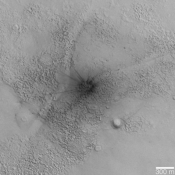
(A) The first picture (above, top left) shows one of the new impact sites identified by the MOC team. Located in northern Arabia Terra near 29.3°N, 333.2°W, the actual crater is quite small, only 11.2 ± 3.0 meters in diameter. This is a sub-frame of MOC image S16-01105, acquired using a ROTO maneuver on 12 March 2006.
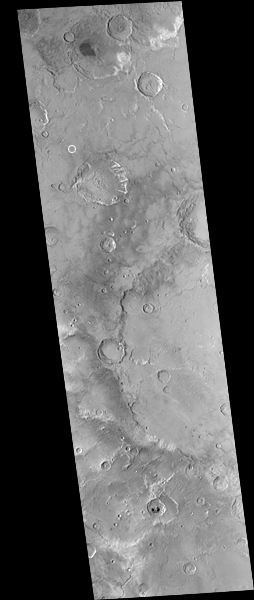
(B) and (C) The second and third pictures (above, top right) are MOC red wide angle camera images, obtained at a scale of about 240 meters per pixel, of portions of Arabia Terra. The first image (in B) is M01-01610 and was acquired during the MOC Geodesy Campaign on 14 May 1999. The second picture (in C), MOC S14-02741, was obtained on 26 January 2006 as part of the campaign to find new impact craters. By comparing the two images, one from 1999 and one from 2006, we were able to identify all new dark spots that formed during that interval. In this case, the new dark spot seen in the 2006 image, S14-02741, is inside the white circle. The same location is also indicated by a circle in the May 1999 image, but no dark spot is present there. In both cases, the white circle is about 12 km (7.5 mi) across.
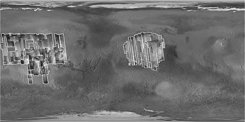
(D) The fourth figure (above, middle) is a map of Mars, showing the location of all the MOC red wide angle camera images acquired for the search for new craters during January through March 2006. These images cover most of Amazonis, Tharsis, and Arabia Terra. The base map is a product that combines the May/June 1999 MOC red wide angle data (plus later data for the south polar region) and laser altimeter data from MGS.
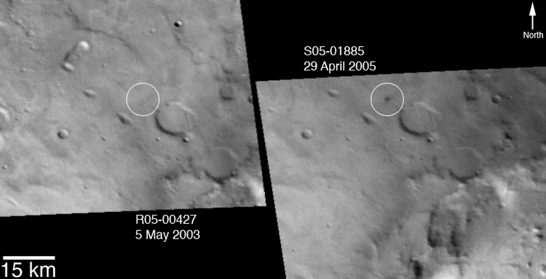
(E) The last picture (above, bottom) shows portions of two red wide angle camera context images that more tightly constrain when the new crater shown here (above, top, left) formed. The first picture, R05-00427, was acquired on 5 May 2003 and shows no dark spot at the site of the impact. The second picture, S05-01885, shows that the dark spot was present on 29 April 2005. Thus, these two images tell us that the impact occurred sometime between those dates: 5 May 2003 and 29 April 2005.
Accompanying captioned releases and other material regarding present-day impact cratering on Mars:
- Catalog of New Impact Sites on Mars Formed May 1999 – March 2006 (PDF)
- How We Found the First of the Fresh Impact Sites:
that Formed During the Mars Global Surveyor Mission
- One of Two Fresh Impact Crater Sites With “Before”
and “After” Narrow Angle Mars Orbiter Camera Images
- New Impact Crater in Arabia Terra
- Fresh Crater in Arabia Terra With Light-Toned Ejecta
- Second of Two Fresh Impact Crater Sites With “Before”
and “After” Narrow Angle Mars Orbiter Camera Images
- New Impact Crater Formed Between April 2001 and December 2003
- Supporting MOC Data
Malin Space Science Systems and the California Institute of Technology built the MOC using spare hardware from the Mars Observer mission. MSSS operates the camera from its facilities in San Diego, California. The Jet Propulsion Laboratory's Mars Surveyor Operations Project operates the Mars Global Surveyor spacecraft with its industrial partner, Lockheed Martin Astronautics, from facilities in Pasadena, California and Denver, Colorado.
 To MSSS Home Page