-
Introduction
6.1. Brief Overview
6.2. Mapping Orbit Design
-
6.2.1. Sun-Synchronicity Choice
6.2.2. Altitude and Inclination Choice
6.2.3. Frozen Orbit
6.2.4. Ground Track Repeat Cycle
6.2.5. Orbital Elements
6.2.6. Sun and Earth Obscuration Geometry
6.2.7. Important Seasonal and Orbital Events
6.4. Data Collection Strategy
-
6.4.1. Data Collection Strategy for Recorded Data (S&E1)
6.4.2. Data Collection Strategy for Real-time Data (S&E2)
6.4.3. Dedicated Science Campaigns (S&E2)
-
6.5.1. Autonomous Eclipse Management Overview
6.5.2. AEM Daily Playback Script Definition
6.5.3. AEM High-Rate Real-time S&E-2 Script Definition
6.5.4. Sequencing with AEM
6.5.5. OTM Sequencing
Introduction
Mapping phase represents the period of repeated, concentrated science observations and data return from Mars. Although some science observations will be performed during aerobraking, most of mission's data will be gathered during mapping. This phase will begin after aerobraking, but not before the spacecraft has been delivered to the mapping orbit, configured for mapping observations, and declared ready to begin collecting science data. Based on the current aerobrake and transition to mapping orbit design, normal mapping operations will begin on 9 April 1998 and will end one Martian year (687 days) later on 25 February 2000. These dates assume a launch at the open of the launch period on 4 November 1996. For a launch at the end of the launch period on 25 November 1996, mapping start will not occur until 18 April 1998.6.1. Brief Overview
Mars Global Surveyor will utilize a Sun-synchronous mapping orbit at a 378 km index altitude with a descending node orientation of 2:00 p.m. with respect to the fictitious mean Sun. In this 92.9° inclination orbit, the MGS spacecraft will circle the red planet once every 117.65 minutes. At all times, the spacecraft will keep its science instruments (+Z panel of the spacecraft) nadir pointed to enable data recording on a continuous basis. On a daily basis, the spacecraft will transmit its recorded data back during Earth during a single 10 hours Deep Space Network (DSN) tracking pass. An articulating high gain antenna (HGA) on the spacecraft will allow data recording to proceed while downlink to Earth is in progress.Once every seven Martian days (sols), the spacecraft will approximately retrace its ground track. After each seven sol "repeat" cycle (88 orbits), the ground track pattern will be offset by 59 km eastward from the tracks on the previous cycle. Such a repeat cycle scheme will eventually allow 99.9% global coverage to be built up from repeated instrument swaths across the planet.
The figure on the opposite page shows a timeline of the mapping phase, including the Martian seasons and the expected data rate profile for return of the recorded science data. Under normal conditions, no major maneuvers will occur during this phase of the mission.
6.2. Mapping Orbit Design
Designing the proper mapping orbit to fulfill the science objectives, and to comply with Mars planetary protection requirements required taking many constraints into account. Section 3 of the MGS Investigation Description and Science Requirements Document (ID-SRD, JPL D-12487 or MGS 542-300) contains detailed information regarding the trajectory related science requirements. In general, the ID-SRD requirements are satisfied by a low-altitude, near-circular, near-polar, Sun-synchronous orbit with a "short" repeat cycle.Specifically, the baseline mapping orbit chosen for the MGS mission will utilize a descending node orientation of 2:00 p.m., index altitude of 378 kilometers, near circular eccentricity of 0.007, inclination of 92.87 degrees, and argument of periapsis of -90o. This combination results in a frozen orbit with a period of approximately 117.65 minutes. In other words, the frozen orbit condition causes periapsis to always remain at -90o, a location over the Martian south pole.
6.2.1. Sun-Synchronicity Choice
In general, the Mars Orbiter Camera (MOC) desires a orbit with a node time late in the afternoon for longer shadows, but the Thermal Emission Spectrometer (TES) prefers an orbit closer to 1:00 p.m. to maximize signal-to-nose ratio. Also, the Magnetometer (MAG) requirements call for an orbit fixed in local time to minimize the impact of large scale ionospheric currents on the observations. The 2:00 p.m., descending node, Sun-synchronous orientation of the mapping orbit represents a compromise between the MOC and TES also acceptable to the MAG.6.2.2. Altitude and Inclination Choice
Constraints on altitude and inclination are primarily driven by the MOC and Mars Orbiter Laser Altimeter (MOLA). The MOC requires an average mapping orbit altitude less than 540 km to guarantee image resolutions better than 2 meters per pixel, while the MOLA needs an orbit inclination within 3° of polar with altitude variations less than 105 km.Use of a 378 km index altitude for mapping operations satisfies the MOC low altitude requirement. Index altitude is a measure of the mean semi-major axis, and reflects the difference between the semi-major axis length and the equatorial radius of Mars (3397.2 km). This parameter is related to, but not the same as the average height of the spacecraft above the surface of Mars. The 378 km number was chosen in large part for its desirable properties with respect to ground track repeat cycles and spacing.
Setting the semi-major axis to a specific value constrains the valid choices for eccentricity and inclination in terms of the spacecraft maintaining a Sun-synchronous orientation. Although many possible solutions exist, MGS will fly in a 92.87° inclination orbit with an eccentricity of 0.007. These parameters satisfy the MOLA constraint for a near polar, near circular orbit with minimal altitude variations.
6.2.3. Frozen Orbit
One of the biggest advantages for the choice of semi-major axis, inclination, and eccentricity described above is that the mapping orbit can subsequently be "frozen" by setting the argument of periapsis to -90o, almost directly over the Martian south pole. This orbital configuration will keep the mean values for eccentricity and argument of periapsis fixed. Essentially, the secular motion of periapsis due to J2 is canceled by the long period variation due to the J3 component of the gravity field.For the MGS frozen orbit, the range of areocentric altitudes over a single orbit will always remain between 354 km (south pole) to 410 km (north pole), satisfying the MOLA constraint for less than 105 km altitude variation. Without the frozen orbit, the variations in eccentricity and periapsis location will cause the altitude range to exceed the horizon sensor's (MHSA) operational limits of 335 km minimum to 455 km maximum. Such an excursion would also violate the MOLA's 105 km altitude variation constraint.
A frozen orbit with a +90° argument of periapsis (over the Martian north pole) is also mathematically possible. However, this option was not chosen because it would force the eccentricity to taken on a higher value than 0.007. Consequently, the orbit would appear less circular in shape and the altitude variations over the course of the orbit would correspondingly increase.
6.2.4. Ground Track Repeat Cycle
The orbital characteristic most directly influenced by the selection of the mapping orbit altitude is the short repeat cycle as dictated by the ID-SRD constraints. A 378 km index mapping altitude yields an 88 revolution near-repeat cycle lasting about 7 about sols. In other words, the pattern of ground tracks under the spacecraft will nearly repeat every 88 orbits.Figure 6-2: Mapping Orbit Ground Track Pattern for 7 Sol Repeat Cycle
Technically, the mapping orbit will be targeted for a Q value of 6917/550. This parameter denotes the number of revolutions completed by the spacecraft in one Martian day. Therefore, if the mapping orbit is perfectly maintained, the ground track pattern will repeat exactly after a "super-cycle" of 6917 orbits in exactly 550 sols. However, maintaining this pattern is not possible due to navigational uncertainties in controlling and predicting the orbit. Atmospheric drag represents the most difficult orbit perturbation to measure.
In practice, the Q value of the mapping orbit will be roughly 88/7. Since 88/7 represents only an approximate fractional reduction of 6917/550 (12.57143 vs. 12.57636), the ground track pattern will not repeat exactly on every cycle. Instead, after every 88 orbit repeat cycle, the ground track pattern for that cycle will appear offset slightly to the east of the pattern laid down by the previous cycle. This offset amounts to 58.6 km when measured at the equator. For example, the equatorial location of ground track number 89 will lie 58.6 km to the east of track number 1. This 58.6 km differential is called the "orbit- walk."
Keep in mind that this 58.6 km orbit-walk at the equator does not represent the spacing between ground tracks on two successive orbits. During each mapping orbit lasting 117.65 minutes, Mars spins under the orbit from west to east at a rate of approximately .24o/minute. This rate of planetary rotation causes the spacecraft to fly over locations about 28.62° to the west of the locations flown over on the previous orbit. At the equator, 28.62° translates to a ground track spacing of 1,697 km between two successive orbits. Ground tracks laid down by later orbits within the 88 orbit repeat cycle will gradually fill the 1697 km gap between two consecutive orbits.
6.2.5. Orbital Elements
Orbital data presented in this section corresponds to a frozen mapping orbit with a mean eccentricity of 0.00719. This value of eccentricity was determined using a Martian gravity field model composed of only the second and third zonal harmonics (J2 and J3) extracted from the Balmino 18 x 18 gravity field model. Once the mapping orbit is achieved after aerobraking, a new gravity field model will be derived from radiometric data collected during gravity calibration activities preceding the start of normal mapping operations. Subsequently, a maneuver will adjust the mapping orbit to be consistent with the new gravity field.The next table lists the orbital elements of the mapping orbit, both mean values and osculating at periapsis. All values are referenced to the Mars centered, Mars mean equator and IAU vector of epoch coordinate system, reference epoch 1 January 1998 at 0:00:00 ephemeris time (ET).
Orbital Element                      Mean Value          Osculating at
                                                         Periapsis

Semi-Major Axis (a)                  3775.144 km         3776.159 km
Eccentricity (e)                     0.00719             .00405
Inclination (i)                      92.866°             92.869°
RA of Asc. Node (Omega)              Varies (see below)  Varies (see below)
Argument of Periapsis (omega)        -90.0°              -90.0°
Because MGS will circle the red planet in a Sun-synchronous orbit, the right ascension of the ascending node (Omega) will advance with time at a rate that matches the mean motion of Mars around the Sun. The expression below provides a way to calculate Omega at any arbitrary time during the mission.
Omega = -98.382323° + 0.5240429(t - to) - 2.644269x10⁻⁶(t - to)
In the previous expression for right ascension of the ascending node in the mapping orbit, t is in Earth days, to is 10 September 1997 at 0:00 ET, and Omega is in degrees referenced to the Mars mean equator, IAU vector coordinate system. Keep in mind that the 2:00 p.m. orientation is with respect to the position of the fictitious mean Sun, not the location of true Sun. With respect to the true Sun, the descending node time of the orbit will vary from about 1:08 p.m. to 2:41 p.m. depending on the Martin season and Mars' exact location in its orbit around the Sun.
6.2.6. Sun and Earth Obscuration Geometry
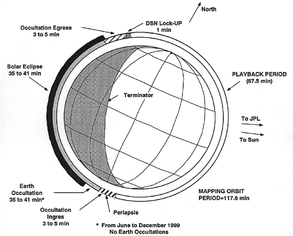
The percentage of time during the mapping orbit when Mars obscures the spacecraft's view of either the Earth or Sun will directly impact spacecraft sequencing and the data gathering and return strategy. Obscuration durations depend directly on the beta angle to the target in question. Target betas measure the angle between the plane of the orbit and a vector to the target, either the Sun or Earth. In other words, the beta angle provides a measure of the angular distance between the target and mapping orbit plane. Specifically, the beta angle is 90° minus the angle between the vector to the target and the angular momentum vector of the orbit.Figure 6-3: Earth and Sun Relative Positions to Mapping Orbit
If an orbit appears "face-on" to the target (view from the target perpendicular to the plane of the orbit), the beta angle will measure 90° and no obscuration of the target occurs as seen from the spacecraft will occur. In other words, the spacecraft will spend no time "behind" Mars relative to the target. Beta values for no obscuration can fall lower than 90° with a high enough orbital altitude. If an orbit appears "edge-on" to the target (view from the target parallel to the plane of the orbit), the beta angle will measure 0° and the target will be obscured for a maximum about of time. As a general rule of thumb, longer obscurations will result when the target is closer in position to the mapping orbit plane than when farther away.
Because the mapping orbit lies fixed at a 2:00 p.m. orientation relative to the fictitious mean Sun at Mars, a 90° beta angle means that the target lies at either 8:00 a.m. (90° west of the orbit) or 8:00 p.m. (90° east of the orbit). On the other hand, a 0° beta angle indicates that the target's position in the sky also lies at 2:00 p.m. relative to the mean Sun at Mars. In general, this type of analogy requires the use of caution because 15° of beta angle does not always translate into one hour of mean solar time differential. The reason is that while the fictitious mean Sun always lies in the Martian equatorial plane, the target may not lie there.
Earth Occultations
During the mapping phase, the position of the Earth will change drastically with respect to the mapping orbit plane. Earth occultation durations will last for roughly 40 minutes out of every 117.65 minute orbit at the start of mapping in April 1998. At this time, the Earth's position will be at about 12:30 p.m. relative to the fictitious mean Sun at Mars, roughly 15° to the west of the mapping orbit plane.
Figure 6-4: Earth Occultation Durations During Mapping
As time progresses forward from the start of mapping, the Earth will gradually move eastward toward the mapping orbit plane, and occultation durations on every orbit will increase as the beta angle drops to 0° on 29 October 1998. On that date, the orbit plane will appear "edge-on" to the Earth, and occultation durations will reach a maximum of 41.3 minutes out of every revolution.
About three and one half months later on 19 February 1999, the Earth's position as seen from Mars will pass through the orbit plane yet another time, but this time on its way back west from the east. Again, occultation durations will reach a maximum due to the "edge-on" orbital geometry. Then, the occultations will slowly decrease in duration as the Earth continues to move westward, away from the mapping orbit plane.
Fourth months later on 19 June 1999, the Earth will reach a position nearly 70° to the west of the mapping orbit, roughly 9:05 a.m. relative to the fictitious mean Sun. This date is significant because despite not yet reaching a "face-on" orientation to Earth, the orbit lies at sufficiently high altitude that the spacecraft will no longer passes behind Mars relative to Earth. In other words, Earth occultations will no longer occur during any part of the mapping orbit, and a clear line of sight will always exist between the Earth and spacecraft.
The Earth's position as seen from Mars will continue to move westward until 22 September 1999 when it reaches an extreme of 8:50 a.m. relative to the fictitious mean Sun. Then, the Earth will begin to move back toward the east. Occultations will begin to occur again on 26 November 1999 and will increase in duration for the remainder of the mapping phase of the mission.
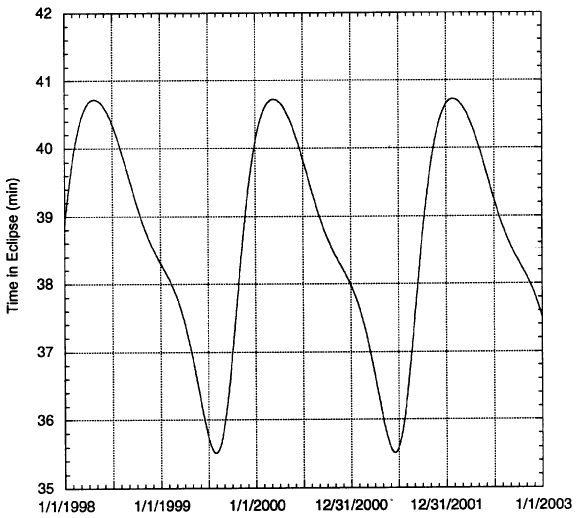
Figure 6-5: Solar Eclipse Durations During Mapping
Solar Eclipses
Despite using a Sun-synchronous mapping orbit, the position between the MGS orbit plane and the Sun will vary as a function of time. Consequently, both the solar beta angle and the amount of time that Mars eclipses the Sun during an orbit will also vary. The reason is that the 2:00 p.m. Sun-synchronous orientation is defined with respect to the fictitious mean Sun.
In reality, Mars' obliquity and the eccentricity of Mars' orbit around the Sun cause the position of the true Sun to oscillate about the mean Sun. This position will vary depending on the Martian season and the location of Mars in its orbit around the Sun. During mapping phase, the true Sun's position will vary from a maximum of roughly 51 minutes ahead (east of) to a minimum of about 41 minutes behind (west of) the fictitious mean Sun. Because the mapping orbit plane lies two hours ahead of the fictitious mean Sun, the true Sun will always be to the west during mapping despite the positional variations.
The longest amount of time during one orbit that Mars eclipses the Sun occurs when the true Sun reaches its most eastern position (closest to the mapping orbit) in late April, early May 1998. At that time, eclipses will last for 40.7 minutes out of every 117.65 minute revolution. On the other hand, the shortest eclipse durations occur when the true Sun arrives at its most western position (farthest away from the mapping orbit) in late July, early August 1999. Then, eclipses will only last for about 35.5 minutes every orbit.
6.2.7. Important Seasonal and Orbital Events
The follow table lists important events from a Mars season and mapping orbit Earth and Sun view geometry perspective.
Date                Event                      Comments

06 February 1998    Winter Solstice            Start of southern summer
30 April 1998       Sun Beta Angle Maximum     Beta angle at -15.909°
04 May 1998         Solar Conjunction          Sun-Earth-Mars angle < 2°
                    Command Moratorium Begins
?? May 1998         Conjunction                Sun-Earth-Mars angle at 0.0°
21 May 1998         Solar Conjunction          Sun-Earth-Mars angle > 2°
                    Command Moratorium Ends
22 June 1998        Earth to Mars Distance     Distance at 2.518 AU
                    Maximum
15 July 1998        Vernal Equinox             Start of northern spring
29 October 1998     Edge-on-Orbit (Diametric   Earth beta angle at 0.0°
                    Occultation)
17 December 1998    Mars Aphelion              Solar distance at 1.666 AU
04 January 1999     Earth Beta Angle Maximum   Beta angle at 4.891°
29 January 1999     Summer Solstice            Start of northern summer
19 February 1999    Edge-on-Orbit (Diametric   Earth beta angle at 0.0°
                    Occultation)
02 May 1999         Earth to Mars Distance     Distance at 0.578 AU
                    Minimum
?? May 1999         Opposition                 Sun-Earth-Mars angle at 180°
01 August 1999      Autumn Equinox             Start southern spring
01 August 1999      Sun Beta Angle Minimum     Beta angle at -39.182°
22 September 1999   Earth Beta Angle Minimum   Beta angle at -77.656°
25 November 1999    Mars Perihelion            Solar distance at 1.382 AU
25 December 1999    Winter Solstice            Start of southern summer
6.3. Spacecraft Configuration
While in mapping, the two solar arrays and the HGA (deployed on a two meter boom) will be gimballed in two degrees of freedom to track the Sun and Earth while the spacecraft moves around the 117.65 minute orbit. In the primary attitude control mode, data from the horizon sensors and the IMU will collectively be used to point the science instrument on the +Z spacecraft panel in the nadir direction, and to point the +X axis in the direction of orbital motion. A backup control mode will also be available to point the spacecraft using data from the celestial sensor and an ephemeris prediction loaded from the ground. Such a scheme will probably require updating the ephemeris on a weekly basis in order to maintain the 10 mrad pointing requirement.A set of three reaction wheels will point the spacecraft under normal circumstances. However, due to atmospheric drag, gravity gradient, and solar pressure torques, the momentum in the wheels will build up and must be periodically unloaded by autonomous thruster firings of the attitude control jets. Most of the unloading burns will occur near periapsis (around the south pole). For typical orbit trim maneuvers (OTM) with a velocity increment in the +X or -X direction, the spacecraft will turn under reaction wheel control to point the desired attitude control thruster in the proper burn direction. A typical OTM will last for several seconds.
6.4. Data Collection Strategy
Two primary modes exist for collecting science data. Most of the time, data gathering will involve continuously recording the data on the solid state recorders and then playing it back to Earth during the daily Deep Space Network (DSN) tracking pass. The other mode will return real-time, high rate telemetry at the 40 ksps rate during additional tracking passes scheduled every third day.As described in Section 2, the S&E-1 and S&E-2 data streams used for science data collection will be Reed-Solomon encoded, resulting in 250 encoded symbol bits for every 218 raw data bits collected by the Payload Data Subsystem (PDS) from the science instruments. Output streams will leave the PDS already Reed-Solomon encoded. Further detail regarding the bit allocations within the data stream can be found in Appendix ??
6.4.1. Data Collection Strategy for Recorded Data (S&E1)
The basic strategy for collecting science during the mapping phase will involve recording both science and engineering data onto one solid state recorder (SSR) on a continuous basis, and then playing back 24 hours worth of data during a 10 hour DSN track pass normally scheduled once per Earth day. Scientific data collection will continue during the playback period to avoid missing portions of the planet that the spacecraft travels over during the playback. This mode is called S&E1.Playback Timing
During the standard, daily 10 hour DSN tracking pass for playback of S&E1 recorded data, the spacecraft will circle Mars every 118 minutes and complete about five orbits. For most of the mapping phase, the spacecraft will enter zones of Earth occultation as it passes behind Mars relative to the direct line of sight to Earth. The time that the spacecraft spends on the "back side of Mars" in the Earth occultation zone will typically eliminate 40 minutes out of every orbit from use for playback of the recorded science and engineering data.
Some additional time when the spacecraft exits occultation will be used for the atmospheric occultation experiment. This process works by transmitting to the Earth through the atmosphere for a range of atmospheric altitudes from zero to 200 kilometers. Because telemetry modulation will be turned off for this experiment to provide maximum signal strength, the duration of this experiment will subtract from the available playback time. Normally, the exit experiment will typically require about five minutes of transmission per orbit. Occultation exit will typically occur near the Martian north pole.
After the spacecraft exits the zone of Earth occultation and completes the radio science experiment, the DSN will require a short amount of time to gain a "signal lock" for modulated telemetry. This time will amount to a maximum of five minutes on the first observed orbit of a tracking pass, but drop to one minute on each subsequent orbit. Then, the spacecraft will be free to downlink its recorded science and engineering data to Earth as it orbits from north to south around the "front" side of Mars.
Another radio occultation experiment will occur on every playback orbit as the spacecraft near the Martian south pole, but before passing behind Mars relative to the Earth and entering the occultation zone. Like the occultation exit experiment previously described, the entry experiment will consume about five minutes of available time for transmission of recorded data.
All of this information leads to the fact that the total available playback time on each orbit of a DSN tracking pass can be determined by taking the orbit period, and subtracting the time the spacecraft spends in Earth occultation, the time allocated for the radio science experiment, DSN lockup time, solid state recorder (SSR) management activities, and navigational uncertainty. With these subtractions, only 67.5 minutes per playback orbit out of the total 117.65 will be available for data return. Therefore, over a period of five playback orbits that elapse during a standard 10 hour DSN tracking pass, a theoretical maximum of 337.5 minutes will be available for downlink (five 67.5 minute segments).
However, several design constraints will reduce the true amount of available downlink time per tracking pass from the 337.5 minute maximum. First, for the purpose of design simplicity, the playback script will only downlink recorded data in discrete 67.5 minute segments. Second, DSN tracking stations will require five minutes to gain a "signal lock" on modulated telemetry the first time the station attempts to listen to telemetry on any given tracking pass. Therefore, in order to avoid potential loss of data during this initial five minute lock-up period, the DSN station must observe the spacecraft for at least a partial 67.5 minute orbit segment before the first whole segment of the actual data playback. Satisfying this constraint will result in only four guaranteed, discrete 67.5 minute segments (270 minutes total) available for playback per 10 hour tracking pass. The net result is that the playback rate must exceed the data record rate by a 5.33 to 1 ratio (24 hours of data in 270 minutes).
Figure 6-6: Typical Profile for Playback Orbit
In order not to "waste" the first partial segment of a tracking pass, the spacecraft will downlink real-time S&E1 data during that time (see Section 2 for a description of that data rate). This data will be the same as that being recorded for the next day's playback. The first five minutes of the real-time data will serve as a "throw-away filler" for the initial DSN signal "lock-up" period. Any additional real-time data returned during the first partial downlink segment of the pass will provide engineering telemetry for the ground monitoring teams to assess the current spacecraft "health" and status. This data is important because the engineering data downlinked during the playback session will represent the spacecraft status up to one day prior.
The possibility also exists that a tracking pass will contain a partial 67.5 minute playback segment after the four whole segments used to downlink the recorded data. This additional time will provide an opportunity to gather more real-time S&E-1 telemetry, or to uplink command updates. Such a scheme will provide additional data for health assessment and command verification.
From 19 June 1999 to 26 November 1999, the MGS mapping orbit will appear "face on" relative to Earth, and no periods of Earth occultation will occur. However, such a geometry will not substantially increase the amount of transmit time available per orbit because of solar eclipse periods. During times when the spacecraft passes through Mars' shadow, the batteries will provide power to run the electronics. Under the current design, running the transmitter throughout the solar eclipse period will drain the batteries to an unacceptably low depth of discharge level.
Data Rates
MGS will utilize playback rates 21.3, 42.7, and 85.3 ksps that correspond to record rates of 4.0, 8.0, and 16.0 ksps, respectively. These rate pairs were selected to match the 5.33 to 1.0 ratio, and to cover the range of expected telecommunications capability as the Earth-to-Mars distance varies over the mapping phase. At maximum Earth to Mars range, the link will only support the 21.3 ksps playback rate. At other times, the operations team will select the highest downlink rate supportable by the link margin. The next table lists the rate mode pairs available for use. Detailed information regarding the bit allocations for each instrument within the S&E1 data stream appear in Appendix ??.
Data Mode           Record Rate         Playback Rate   Single SSR Storage
Low Rate (LRC)      4,000 sps           21,333 sps          104 hours
Medium Rate (MRC)   8,000 sps           42,666 sps          52 hours
High Rate (HRC)     16,000 sps          85,333 sps          26 hours
Substantial record capacity margins exist in the SSRs as each one can store up to 104 hours of data at the 4.0 ksps record rate, and 26 hours at the 16.0 ksps rate. If both SSRs are functional, then it will be theoretically possible to store between 42 and 208 hours of data, depending on the specific record rate. However, downlinking more than 24 hours of recorded data will require a tracking pass longer than 10 hours in duration.
The next table shows an estimate of the dates of usage for the three different data rates over the course of the mapping phase. Availability of a DSN site to support a given rate assumes a 34m-HEF antenna, and greater than a 10 hour view period at the station where the spacecraft elevation, as seen from the antenna, lies at least 10° above the horizon.
Mission Dates       S&E1 Record Rate    S&E1 Playback Rate  Stations Supported (10
                    Code                                    hr. pass)

5-Apr-98 to         LRC1                21,333 sps          Goldstone yes Canberra
23-Sep-98                                                   no Madrid yes
23-Sep-98 to        MRC1                42,666 sps          Goldstone yes Canberra
9-Dec-98                                                    yes after 25-Nov-98
                                                            Madrid at LRC1 until
                                                            28-Oct-98 Madrid at MRC1
                                                            after 28-Oct-98
9-Dec-98 to         MRC2                42,666 sps          Goldstone no Canberra
6-Jan-99                                                    yes Madrid no
6-Jan-99 to         HRC1                85,333 sps          Goldstone no Canberra
10-Nov-99                                                   yes Madrid no
10-Nov-99 to        MRC3                42,666 sps          Goldstone no Canberra
26-Jan-00                                                   yes Madrid no
26-Jan-00 to        LRC1                21,333 sps          Goldstone yes Canberra
21-Feb-00                                                   yes Madrid yes after
                                                            16-Feb-00
For about half of the mapping phase, at least two DSN sites can support MGS tracking at the 10 hour per track requirement . This capability will facilitate the resolution of tracking conflicts with other missions and will provide flexibility in rescheduling should one station go "off-line." However, throughout 1999, only Canberra will possess the capability to support a 10 hour tracking pass because Mars will appear only at southern declinations as seen from Earth during that year. In this case, the problem lies not with the link margin, but with the physical amount of time that Mars will spend above the horizon as seen from the two northern tracking stations. However, due to Mars' close proximity to the Earth during the early to middle part of that year, receiving at the high data rate (85,333 ksps) will be possible from both Goldstone and Madrid with a shorter tracking pass duration.
Only one playback rate will be used over each tracking pass, and that the rate will not increase as the elevation of the spacecraft as seen from the DSN station increases over the first half of the track. The playback can be completed more quickly (or more data could be returned), by adjusting and maximizing the playback rate as a function of time during the tracking pass, but such a scheme will increase the complexity of planning the data return.
6.4.2. Data Collection Strategy for Real-time Data (S&E2)
The MGS mission will also utilize a data rates of 40 and 80 ksps to permit the real-time return of high-bandwidth data that would otherwise be constrained to lower record rates (4, 8, or 16 ksps). Approximately every third day during the mapping phase, an additional 10 hour, 34m HEF antenna tracking pass (as compared to the daily tracking passes) will allow real-time data return. This mode is called S&E2. Although the MGS spacecraft can support an 80 ksps S&E2 data rate if the link margin permits, this rate is not an official project requirement and will only be implemented on a "best-effort" basis only. The 40 ksps represents the nominal S&E2 data rate.Only the Mars Orbiter Camera (MOC) and Thermal Emissions Spectrometer (TES) will utilize this 40 ksps real-time mode. During periods of S&E2 operations, the SSRs will continue to record data in the standard S&E1 mode for daily playback (described in the previous section) to avoid losing Magnetometer (MAG) and Mars Orbiter Laser Altimeter (MOLA) data. Another reason for simultaneous S&E1 recording is that real-time data collection cannot occur in the Earth occultation zone, primarily on the night side of the planet. However, the bit allocations for the different instruments within the S&E1 data stream will be slightly different when simultaneously transmitting S&E2 than during normal record operations. Detailed information regarding the bit allocations for MOC and MOLA within the S&E2 data stream and the modified bit allocations within the S&E1 data stream appear in Appendix ??.
The next table shows an estimate of the dates of usage for the two different S&E2 data rates over the course of the mapping phase. Availability of a DSN site to support a given rate assumes a 34m-HEF antenna, greater than an eight hour view period at the station where the spacecraft elevation, as seen from the antenna, lies at least 10° above the horizon.
Mission Dates       S&E2 Playback Rate  Stations Supported (>8 Hr. Pass)

5-Apr-98 to         40,000 sps          Goldstone yes Canberra
23-Dec-98                               listen-only before 21-Oct-98
                                        Canberra yes after 21-Oct-98
                                        Madrid listen-only before
                                        19-Aug-98 Madrid yes after
                                        19-Aug-98
16-Dec-98 to        80 ,000 sps         Goldstone yes Canberra yes
28-Jul-99                               Madrid yes after 23-Dec-98
28-Jul-98 to        80,000 sps          Goldstone until 18-Aug-99
1-Dec-99                                Canberra yes Madrid no
1-Dec-99 to         40,000 sps          Goldstone yes Canberra yes
21-Feb-00                               Madrid yes after 22-Dec-99
Although a 10 hour view period will be requested from the DSN for the every third day real-time S&E2 track, an eight hour period will suffice when either the link margin will not support a 10 hour DSN pass, or the physical viewing geometry (horizon to horizon) will not support a 10 hour pass. The reason is that the return of real-time data will not require four discrete 67.5 minute transmit segments as in the case of S&E1 playback. Using three discrete segments, plus two partial segments will work as long as the total real-time transmit time totals 270 minutes.
Near the beginning of the mission's mapping phase, the range from Earth to Mars will reach a maximum (2.518 AU on 22 June 1998). For several months before and several months after, the link margin will not support a data rate of 40,000 sps in the normal diplex (two-way) mode from Canberra and Madrid. For S&E2 operations from those two stations during times of maximum Mars range, the DSN will operate in a "listen-only" mode to increase the effective gain of the signal.
6.4.3. Dedicated Science Campaigns (S&E2)
Science campaigns will consist of 10 individual instances of intensive, week-long periods of continuous, real-time S&E2 data return to observe Mars during periods when unique surface and atmospheric conditions occur due to seasonal changes, during periods of special orbit geometry, and for spatial or global coverage issues. All of the 10 campaigns will last for 88 revolutions over a period of roughly seven sols to provide global coverage for a complete orbit repeat cycle.Each campaign will be dedicated to one or more disciplines in the fields of atmospheric studies, diametric occultations, global color imaging, geodesy, and gravity field measurements. In general, the science campaign schedule calls for as many of the "sub-campaigns" corresponding to the various individual disciplines to occur at the same time in order to minimize the amount of continuous tracking requested from the Deep Space Network (DSN). The next table shows the current science campaign schedule for MGS.
Mission Dates       Campaign Code       Disciplines         Mars Season and Comments
2-Mar-98 to         A                   Atmosphere #1       Northern Winter /
9-Mar-98                                                    Southern Summer Observe
                                                            carbon dioxide clouds in
                                                            the northern polar
                                                            regions and the
                                                            initiation of dust and
                                                            winter storms.
29-Jun-98 to        B                   Atmosphere #2       Northern Winter /
6-Jul-98                                Color Imaging #1    Southern Summer Observe
                                                            residual southern polar
                                                            ice cap, close of dust
                                                            storm period.
26-Oct-98 to        C                   Atmosphere #3       Northern Spring /
2-Nov-98                                Color Imaging #2    Southern Fall Observe
                                        Diametric           mid-spring water sources
                                        Occultation #1      and carbon dioxide
                                        Gravity #1          clouds in the southern
                                                            polar regions. Earth is
                                                            in the plane of the
                                                            mapping orbit.
5-Jan-99 to         D1 D2 D3 D4         Geodesy Look 1,     Start of Southern Winter
12-Jan-99                               Pass 1 Geodesy      Atmosphere in both
20-Jan-99 to                            Look 2, Pass 1      hemispheres is clearest
27-Jan-99                               Geodesy Look 1,     at this time. Earth is
3-Feb-99 to                             Pass 2 Geodesy      in the plane of the
10-Feb-99                               Look 2, Pass 2      mapping orbit. Each
18-Feb-99 to                            Diametric           geodesy "week" must be
25-Feb-99                               Occultation #2      separated by multiplies
                                                            of 88 orbits.
3-May-99 to         E                   Atmosphere #4       Northern Summer /
10-May-99                               Color Imaging #3    Southern Winter Observe
                                        Gravity #2          atmosphere profiles near
                                                            the equator and water
                                                            transport across the
                                                            equatorial zone.
27-Sep-99 to        F                   Color Imaging #4    Start of Northern Fall
4-Oct-99                                Gravity #3          Earth out of mapping
                                                            orbit plane angle is at
                                                            a maximum.
13-Dec-99 to        G                   Atmosphere #5       Start of Southern Summer
20-Dec-99                                                   Observe carbon dioxide
                                                            clouds in the northern
                                                            polar regions and the
                                                            initiation of dust and
                                                            winter storms.
Similar to the strategy for collecting real-time data during the "extra" pass every third day as described previously, the solid state recorders (SSRs) will continue to record data in the standard S&E1 mode for daily playback while the spacecraft simultaneously transmits the real-time, S&E2 data stream back to Earth. During each day of a campaign, the current plan involves transmitting S&E2 real-time for two-thirds of the day, and then downlinking the previous 24 hours of recorded S&E1 data in the remaining one-third of the day.
6.5. Planning and Sequencing
6.5.1. Autonomous Eclipse Management Overview
The MGS spacecraft possesses the capability to detect when it enters and exits the shadowed zone behind Mars where the planet blocks the direct line of sight to the Sun. This ability, called autonomous eclipse management (AEM), takes the form of an algorithm that resides in the flight software power task. AEM utilizes power subsystem telemetry inputs, short circuit current, and solar array and battery currents in a majority vote scheme to detect transitions into and out of eclipse to within 12 seconds. Upon detecting these transitions, the flight software will initiate ground specified, pre-loaded command scripts that automatically handle the execution of the radio science experiments and the playback of recorded data.Primarily, the major advantage of using AEM to assist in autonomously returning recorded data is manifested in significant savings in operational planning time due to minimizing the number of scripts needed over the entire mapping phase for playing back data. The following sub-sections describe the implementation of AEM in returning the science data.
6.5.2. AEM Daily Playback Script Definition
Due to the variability in the spacecraft's orbital position at the start of a scheduled playback pass, the time available each non-occulted portion of each orbit, or Earth View Period (EVP), for playing back the recorded science data from the solid state recorder varies. In order to most efficiently use AEM, the playback time per EVP must be set to a fixed duration so that a single script can used. There are approximately five orbits (117.65 minute orbital period) in a ten hour DSN pass. There are guaranteed to be four complete EVPs in a ten hour pass, with the fifth EVP either complete or divided into two partial EVPs at the beginning and end of the pass. A single playback script can be defined if the playbacks are constrained to occur over the four complete EVPs. Summarizing from subsection 6.5.1, 24 hours of recorded science data can be played back in 270 minutes, when utilizing the three paired science data record/playback rates (4/21 ksps, 8/43 ksps and 16/85 ksps). Divided over the four EVPs, the playback duration in the proposed AEM playback script is 67.5 minutes.In addition to the SSR playback, time in the EVPs must also be allowed for the radio science experiments at Earth occultation exit and entry, when the spacecraft appears to pass through the atmosphere from 0 to 200 km and from 200 to 0 km, respectively, as viewed from Earth. For the first 15 months of mapping, the radio science durations each orbit typically require 6 to 9 minutes of transmission time. The radio science experiments require an additional 200 seconds (100 seconds above 200 km at egress and at ingress) each orbit for calibration. For the worst case, when the Earth occultation periods are longest, there is sufficient time in the EVP to sequence all of the above activities.
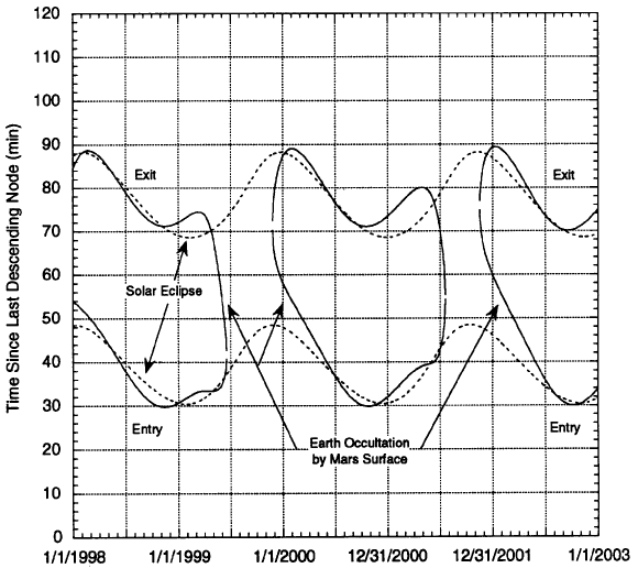
Although AEM initiates scripts on eclipse entry and exit detection, the data return must be timed relative to Earth occultation transitions. Figure 6.9 shows the timing relationship between solar eclipse and Earth occultation. The figure shows that the eclipse and occultation periods generally overlap for most of the mission, except for late in mapping when the orbit is never occulted from Earth. The figure also shows that occultation exit and entry can occur before or after the corresponding eclipse exit and entry, respectively. AEM allows the ability to utilize both eclipse entry and exit detection to trigger separate scripts or to use either one or the other to initiate a single script.
From an operations perspective, it is desirable to develop a single script, triggered off either the eclipse entry or eclipse exit detection, that contains all of the commands to perform the radio science measurements and the recorder playback. However, the relative timing between eclipse and occultation transitions ensures that not all of the commands would be executed before the script was triggered again. To avoid this complication, a two script design approach can be utilized. The first script performs the radio science experiment at egress and the playback of the recorded data, and is timed relative to Earth occultation egress. The second script contains the radio science experiment at ingress and is timed relative to Earth occultation ingress.
Figure 6-7: Timing Relationship Between Earth Occultation and Solar Eclipse
As noted above, since occultation egress can occur before eclipse egress and similarly for the ingress case, the previous eclipse transition must be used to trigger the appropriate scripts. Thus, the radio science at egress and recorder playback script is triggered off of eclipse entry detection and contains a delay time equal to the time between eclipse entry and occultation exit minus the time required to warm up the telecom subsystem. The radio science at ingress script is correspondingly triggered off of eclipse exit detection, and contains a delay time equal to the time between eclipse exit and occultation minus 100 seconds for radio science calibration above 200 km.
Late in the mapping phase, when the spacecraft orbit is never occulted from the Earth, the playback could be performed continuously and not broken into four 67.5 minute portions. However, the spacecraft has power constraints which prohibit continuous transmission in eclipse, so that the strategy outlined in this subsection is still valid. Because there are no radio science experiment opportunities, a single script approach can be utilized however, which performs 67.5 minutes of playback triggered off of the eclipse exit detection.
6.5.3. AEM High-Rate Real-time S&E-2 Script Definition
As described in subsection 6.5.2, every third day an additional ten hour 34-meter (HEF) antenna DSN pass is scheduled to return the high-rate 40 ksps S&E-2 real-time telemetry. In a similar manner as outlined for the playback passes, an additional script is defined that is triggered by eclipse entry detection and timed relative to occultation exit, which executes the radio science commands for the egress opportunity and upon completion initiates the S&E-2 real-time downlink. The S&E-2 real-time downlink continues until the radio science at ingress opportunity, which is triggered by the same script used in the playback passes.6.5.4. Sequencing with AEM
As noted previously, the AEM scripts themselves are generated by the ground and pre-loaded in a reserved area of sequencing memory. The AEM script offset or delay times from eclipse entry to occultation exit (and eclipse exit to occultation entry) are generated by navigation predictions. These times are expected to be very accurate (less than 10 seconds up to 8 weeks in advance), since the times are not absolute event times but the delta-time between orbital events. The frequency of script timing updates is shown in Figures 6.10 and 6.11, which show the change in time between eclipse entry and occultation exit and between eclipse exit and occultation entry, respectively, throughout the mapping phase. Infrequent timing updates on the order of every two to three weeks in the worst case, may be required to keep the eclipse detection synched with the required occultation events.Normal commanding is performed on the spacecraft using stored command sequences. These sequences are generated by the ground using sequence generation software tools, uploaded to the spacecraft, and initiated at the desired time by an "absolute" time-tag. The commands contained in the sequence are executed relative to each other using offset times (i.e., "relative" time-tags). By using AEM, the mapping sequences need only contain the commands to enable the appropriate pre-loaded AEM script on-board the spacecraft, prior to the desired orbit, and not the entire set of commands required to return the data for each scheduled DSN pass. Short-range DSN schedules are generated 8 weeks in advance of the sequence load. Using this DSN allocation file, the appropriate enable commands prior to the start of each scheduled playback pass and high-rate real-time pass (and disable commands upon completion of the pass) are placed in the sequence.
By utilizing AEM, the duration of the mapping stored sequences are no longer driven by the accuracy of the navigation timing uncertainties. Instead the sequence durations are driven exclusively by the availability of an accurate conflict free DSN allocation file and the sequence development time required by the ground to generate and validate the sequences, which should also be significantly reduced due to the decreased number of commands that need to be generated.
6.5.5. OTM Sequencing
Orbit trim maneuvers (OTMs) during the mapping phase will be for the purpose of controlling the spacing of the repeating ground tracks, and correcting the orbit eccentricity and inclination. The orbit inclination is used to control the location of the orbit node. It is currently anticipated that OTMs will be scheduled approximately once every month. These maneuvers will normally be placed near periapsis, although they will occasionally occur near apoapsis. OTMs for inclination control must be executed near the equator.Four-hour windows shall be provided in the mapping sequences for the OTMs. This allows the maneuver time to be selected from two orbits in the event that large gravity anomalies are present on one of the orbits. Spacecraft and payload activities which conflict with the maneuver must be kept out of the window.
6.6. Solar Conjunction
The mapping phase will be interrupted for a period centered about May 13, 1998, when Mars passes through conjunction as seen from the Earth (the minimum Sun-Earth-Mars or SEM angle is 0.8 degrees). Both the uplink and downlink radio signals will be degraded for a period of several days on each side of conjunction. Based on current analysis, it is assumed that the uplink signal will be unacceptably degraded for commanding when the Sun-Earth- Mars or SEM angle is less than 2 degrees. This is a 17-day period from May 4, 1999, through May 21, 1994, when a command moratorium will prohibit commanding. The spacecraft can operate autonomously, maintaining all its normal engineering functions, including nadir pointing, without commanding over this 14-day period. Over much of this period, it is unlikely that telemetry can be received successfully at the lowest S&E-1 playback rate of 21.3 ksps. For these reasons, tape recorder playbacks are not planned during most of the solar conjunction period.The current plan is to design a solar conjunction sequence that will provide real-time spacecraft telemetry when the solar array is illuminated and the opportunity to acquire navigation Doppler data during a single DSN tracking pass each day. A special AEM script will be developed to turn the transmitter on and return real-time telemetry for this period. This strategy allows for daily health assessment of the spacecraft and the payload, radiometric monitoring of the orbit, and limited science observations on the day side of the planet whenever telemetry can be received on the ground.
Realtime performance at the lowest science collection rate of 4 ksps (S&E-1 LRC) may not even be achievable throughout the period. Because of this, and because of the desire to have at least some spacecraft health status each day, a composite data return strategy of 250 bps and 4 ksps has been designed. For the first ten minutes of each orbit, engineering-only telemetry will be returned at 250 bps. For the rest of the orbit, 4 ksps S&E-1 will be returned in realtime. Radio Science atmospheric occultation measurements will also be performed during conjunction. During the Radio Science segments of each orbit, the transponder will be 1-way with telemetry and ranging modulation off, while for the rest of the orbit, the transponder will be configured with telemetry and ranging on, and with 2-way tracking enabled. As the conjunction geometry becomes more extreme, the uplink carrier may not be transmitted from the ground and one-way Doppler data, referenced to the USO, will be measured at the DSN. This will reduce noise on the downlink, as the signal makes only one pass through the solar corona, rather than two. Later, as the geometry improves, two-way data collection will resume. The data return profile described above will be repeated for each orbit during solar conjunction, even though tracking requirements are only for one 34-m HEF pass per day. If anomalies or any other circumstances indicate that additional coverage is warranted, downlink from the spacecraft will be available without emergency commanding.
When commanding again becomes possible after the conjunction, normal mapping data return will begin.
To Mission Plan Table of Contents
To Previous Section
To Top of This Section
To Next Section
 Return to MSSS
Home Page
Return to MSSS
Home Page