JPG = 46 KBytes
GIF = 165 KBytes
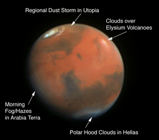
Figure 1: Mars (April 1995) displays a rich assortment of atmospheric phenomena
2. SCIENTIFIC OBJECTIVES
2.1. Atmospheric Studies
2.1.1. Clouds
2.1.2. General Circulation
2.1.3. Interannual Climate Variations
2.1.4. Dust Storms
2.1.5. Polar Processes
2.1.6. Atmospheric Opacity
2.2. Studies of Surface/Atmosphere Interactions
2.2.1. Dust Storm Activity
2.2.2. Variable Features Resulting From Dust Transport
2.2.3. Variable Features Resulting From Sand Transport
2.3. Surface Studies
2.3.1. Morphology and Pattern
2.3.1.1. Eolian Sediments and Morphology.
2.3.1.2. Polar Deposits
2.3.1.3. Mid- and Low Latitude Deposits
2.3.1.4. Non-eolian Morphology
2.3.2. Composition
The primary objectives of this investigation are to: 1) observe martian
atmospheric processes at global scale and synoptically, 2) study
details of the interaction of the atmosphere with the surface at a variety of
scales in both space and time, and 3) to examine surface features
characteristic of the evolution of the martian climate over time. These
objectives will be met through the acquisition of images over a range of time-
and spatial scales.
Atmospheric investigations will include studies of: a) the distribution of
dust, condensates, and ozone in the atmosphere, b) the structure of condensate
clouds and their relationship to topography and to circulation patterns
predicted by global circulation models (GCMs), c) dust storms ranging in
magnitude from localized clouds to planet encircling storms, and d) polar
phenomena.
Among the major scientific questions to be addressed are:
1. What is the seasonal and geographical variability in dust, ozone, and
condensates in the martian atmosphere?
2. What is the general circulation of Mars? How reliable are the predictions
of GCMs, and how much interannual variability exists?
3. What role do clouds in general, and the polar hoods in particular, play in
the global water cycle on Mars? Do they control the net interhemispheric
transfer of water?
4. How do local, regional, and global dust storms evolve? How are they related
to the local, meso-, and synoptic-scale circulations?
5. How are the seasonal and residual caps involved in the global transport of
water and dust on Mars? What is the direction of the net annual water
transport on the planet?
Clouds probe many important properties of the martian atmosphere and may be
used to test dynamical atmospheric models. The distribution of clouds depends
in part on the global distribution of atmospheric water (both absolute content
and relative saturation), and can be used to extract information about the
water distribution when independent constraints can be obtained from
atmospheric temperatures. The distribution of clouds also depends on the
regional and local dynamics of atmospheric circulation, in turn dependent on
heat transport processes in the atmosphere that respond to the transport of
dust and condensates. Thus, clouds can also be used to probe these transport
mechanisms. Global, synoptic observations are the best way to study the
geographical and temporal distribution of martian clouds in a manner that
allows them to be used to constrain circulation models. In addition,
multispectral observations, when combined with modeling of the physical and
chemical attributes of atmospheric constituents that affect color, can address
questions of cloud optical depths and water content.
The general circulation of the martian atmosphere determines the
transport of dust and water around the planet which can significantly
affect the rate at which CO2 condenses at the poles
(Pollack et al., 1990; 1993). Studies of the general circulation on
Mars are relevant to terrestrial GCMs because of the similar diurnal
and seasonal cycles but different compositions and masses for the two
planets. Unfortunately, observations pertinent to the general
circulation on Mars lack the spatial and temporal density needed to
describe it. Thus, a primary goal of this investigation is to help
describe the structure and variability of the general circulation.
Winds can be determined from imaging data by tracking cloud systems and dust
storms, and can also be inferred from topographically generated gravity wave
trains whose wavelengths are diagnostic of the local wind field. Of course,
such observations are unable to describe the full three-dimensional
structure of the general circulation, since they depend on aerosols and
condensates as "tracers" to "see" the wind field. These materials actively
participate in creating the conditions that generate the field in the first
place. However, both at global and regional scale the effects of these
materials can be relatively small. Previous experience on Mars suggests that
they can be used to follow atmospheric motion.
One very important feature of the general circulation that will be addressed is
the nature of traveling baroclinic wave systems. GCMs suggest that they may be
much less vigorous in the southern hemisphere during winter than in the
northern hemisphere, owing to hemispheric differences in topography (Barnes et
al., 1993). It is necessary to characterize the dominant zonal wave numbers,
phase speeds, and meridional structure of these systems in both hemispheres if
the general circulation models are to be validated.
Models also predict that, at least in the northern hemisphere, baroclinic
disturbances should grow and decay in preferred longitudinal regions called
"storm zones" (Hollingsworth et al., 1995; Barnes et al., 1995). In these
regions, the poleward fluxes of heat and momentum are maximized and dust and
water transport should be as well. Topography is mainly responsible for the
stationary eddies and should produce inter-hemispheric differences in storm
zone patterns. Atmospheric opacity and cloud frequency and optical properties
should reveal these zones as persistently dustier and cloudier regions. Models
also predict that the martian Hadley cell is much more longitudinally variable
than previously thought. In particular, the meridional flow in the lower
branch of the Hadley cell should be channeled into narrow currents along the
eastward flanks of major topographic rises such as Tharsis. Imaging data can
be used to test this model prediction.
Ground-based temperature profiling and Hubble Space Telescope (HST) imaging
since 1988 show much colder atmospheric temperatures and lower dust loading
than during the Viking mission (Clancy et al., 1990; James et al., 1994). This
distinction appears most significant for the northern Spring/Summer season of
Mars (around Mars aphelion); the typical behavior of the Mars aphelion
atmosphere may include low dust loading, reduced atmospheric temperatures, low
altitudes water vapor saturation, and a 10° S to 30° N global belt of
moderate opacity clouds (Clancy et al., 1995a). Low altitude saturation may
impede transport of water into the southern hemisphere during this season and
thereby have a significant impact on the global water distribution. The Mars
Surveyor '98 Orbiter mission permits an imaging experiment to make observations
relevant to several important aspects of this purported "new climate". Not
only can the direct seasonal variation of clouds be observed, but also
indirectly related properties such as limb measurements of atmospheric ozone
concentration which, by providing a proxy for water saturation altitudes, can
be used to address the variability issue.
Global maps are important for monitoring all but the smallest scale dust
activity on Mars. Viking observations showed that local sand or dust storms
are fairly common in certain locales and during certain seasons on Mars, e.g.
at the edge of the south polar cap in Spring, in Hellas and Argyre Basins, in
the Solis Planum region, etc. On rare occasions during the Viking mission,
single storms were monitored with sufficient temporal sampling density to
determine the evolution of these events. However, major questions remain about
the diurnal development of local storms, especially in the polar regions.
The expansion of global storms has been observed from Earth as well as by
Viking using sequences of images (Martin, 1976), and the path of a large
regional storm in the northern hemisphere was deduced from Viking sequences
obtained on three consecutive days in 1978 (James, 1985). Observation of Mars
for one year at a scale of better than 10 km should be sufficient to define the
global dust cycle for that year and help to identify sources and sinks for
dust. Coupled with a successful MGS MOC experiment, this would provide
complete records of two consecutive seasonal dust cycles that could then be
applied to addressing the circumstances that lead to planet encircling storms
and why the dust cycle shows such interannual variability.
There also remain significant issues regarding dust processes at smaller
scales. Little is known about dust devils of the type observed by Thomas and
Gierasch (1985) and, indirectly, by Ryan and Lucich (1983) using Viking Lander
meteorology. Regions where local dust storm activity is known to occur, such
as preferred longitudes at the edge of the receding spring caps, are likely
sites for dust devil activity. Inspection of these areas might shed light on
how local storms are started, and how topography, surface, local sources of
dust, and other physical factors participate in their generation.
The annual cycles of the martian polar caps are the most obvious seasonal
signpost on the planet, having been recognized as such by Herschel (1784). A
good data set at 1 km/pixel resolution was obtained by Viking Orbiter 2 for the
south cap (James et al. 1979), while the best spacecraft views of a north polar
recession were obtained by Mariner 9 and HST. Neither spacecraft nor
Earth-based imaging have provided much information on the deposition of either
cap because most condensation takes place during polar night. However, this
does not mean visible monitoring is unimportant. Global monitoring using a
multispectral, wide angle camera for an entire martian polar cycle would
provide important clues to polar processes by showing the relationships between
the polar hood and cap edges, even if the waxing pole were not illuminated.
The observational situation is somewhat better for the residual, late summer
phases of the polar caps. Untangling the physics of the residual caps is one of
the most interesting problems in Mars science because of the dichotomy in
composition between the water ice north cap and the (at least partially) dry
ice south cap. Involved in this puzzle are clues to the water cycle on Mars;
net annual transfer of water from one hemisphere to another may be revealed by
interannual changes in the residual caps. Such changes were seen in a
comparison of the very good Mariner 9 and Viking data sets, and two additional
data sets from MGS and the Mars Surveyor '98 orbiter could provide not only two
additional reference points for identification of possible monotonic or cyclic
variations with periods greater than one Mars year, but also such reference
points at considerably finer temporal and spatial resolution. The residual
polar caps should be monitored at medium resolution (tens of meters per pixel)
in order to study the fractional coverage of the surface and to estimate the
thickness of the frost deposits.
Observing the reflectivity of surface frost at several wavelengths and at a
variety of photometric angles is pertinent to deducing the nature of the ice
surface, and changes in the frost albedo as a function of wavelength can be
compared to the atmospheric opacity to attempt to correlate changes in the
frost surface with dust deposition and other seasonal and geographic variables.
Various regions near the edge of the seasonal caps should be observed on
consecutive days at medium resolution to high spatial resolution in order to
observe the sublimation (and condensation) processes as the edge of the cap
passes those particular points. In addition, regions in the cap's interior
should be observed to test the hypothesis that albedo variations within the cap
are due primarily to fractional coverage of the surface. Specific locations
within the cap such as the Mountains of Mitchel, craters with frost streaks,
and craters with dunes within them are excellent candidate locations, as they
have been observed on previous missions to lend credibility to the
aforementioned hypothesis, although not with the time and space resolution
afforded by the Mars Surveyor '98 opportunity.
A particularly exciting capability that is proposed here is mapping the entire
planet, daily and at a nadir scale of better than 7 km/pixel, at ultraviolet
wavelengths. UV imaging has the advantage for atmospheric purposes of
minimizing the contribution to the reflectance from the surface of Mars because
of its very low UV albedo and lack of variation in same. Most of the
reflectance at these wavelengths results from scattering and absorption in the
atmosphere. Inasmuch as the Rayleigh contribution can be calculated exactly,
contributions from aerosol scattering can then be isolated to the extent that
the phase functions for those processes are known or can be approximated. In
addition, comparison of reflectances at, for example 250 nm (deep within the
Hartley band) and 330 nm (which is unaffected by ozone absorption), can be used
to estimate atmospheric ozone, which also constrains the amount of water vapor
through photochemistry. This method has been successfully used in analyses of
the HST Mars data set (James et al., 1994)
Given the current lack of fluvial activity on Mars, processes involving
surface/atmosphere interactions (SAI) are the primary agents of surficial
change at present. Manifestations of SAI include regional and global-scale
dust storm activity, the variability of surface albedo features related to
eolian transport of dust and sand, and the condensation/sublimation of
volatiles at the surface. The accumulated historical evidence (ground-based,
spacecraft, and HST observations) indicates that a great deal of seasonal and
interannual variability exists in eolian activity on Mars. Returning data for
more than one Martian year will significantly expand the temporal observations
that are crucial to understanding the seasonal, interannual, and long-term
efficacy of SAI. In addition, multi-wavelength capabilities can yield
observations not possible from previous spacecraft. The combination of
regular, repeatable global mapping (using a wide angle camera) and selected
detailed observations (with a medium resolution camera) allows the temporal and
spatial resolution, and the multispectral observations, necessary to
significantly expand understanding of many of the details of SAI on Mars.
Dust storms are the primary source of short-term changes in the appearance of
Mars at present, providing the driver for the numerous surface features
attributed to eolian processes. Understanding eolian processes on the planet
requires knowledge of the location, genesis, timing, and frequency of dust
storms. The historical record indicates that local dust storms can occur at
any season, while great dust storms of global extent are most common near Mars'
perihelion (Slipher, 1982; Zurek, 1982; Martin, 1984; Peterfreund, 1985);
it is also evident that a great deal of interannual variability exists in the
timing, location, and extent of dust storms.
Regularly repeated global mapping by the low resolution, wide angle
camera is the primary method of monitoring dust storm activity, being
of sufficient spatial and temporal resolution to allow detailed
mapping of dust storm timing, location, and evolution. Coupled with
contemporaneous information on dust loading obtained by PMIRR, camera
observations from the Mars Surveyor '98 orbiter will provide
unprecedented insight into the processes involved in Martian dust
storms. Where dust storms are detected, observations at medium
resolution can be targeted for detailed investigation of the surface
where storms arise. A multispectral capability is important for
distinguishing between dust and condensate clouds, and for
investigating mixtures of the two. Equally important will be the
expansion of the historical record of dust storm monitoring, adding
more than one Martian year of semi-continuous monitoring. If dust
storms are observed by MGS during the preceding Mars' year, Mars
Surveyor '98 will be in the position to provide detailed
characterization of the source regions and give insight into the
repeatability of dust storm activity.
There is abundant evidence that, at present, eolian processes are
active over most of the surface of Mars (cf. Veverka et al., 1977;
Thomas et al., 1981). A wide variety of surface features, such as
wind streaks, sand dunes, and regional albedo features, are attributed
to eolian deposition and erosion. Previous studies have demonstrated
that variations in regional albedo and wind streak patterns are
indicative of sediment transport through a region (e.g., Figure 2(Lee et al., 1982, 1994; Kahn et al., 1992),
while thermal inertia data (derived from Viking IRTM and to be derived
at high spatial resolution by the TES on MGS) are indicative of the
degree of surface mantling by dust deposits (Kieffer et al., 1977;
Christensen, 1982, 1986a,b, 1988; Jakosky, 1986). Experimental
studies (Wells et al., 1984) show that small amounts of dust
deposited/eroded from the surface can explain the observed surface
albedo changes (modifying surface dust cover by less than a micron of
dust can alter the albedo by several tens of percent). The colors of
martian albedo features can also be related to variable amounts of
dust cover (Soderblom et al., 1978; Singer and McCord, 1979; McCord et
al., 1982a,b). Visual data are therefore diagnostic of net erosion or
deposition of dust-storm fallout that is taking place currently;
combined with available thermal data, inferences can be made as to
whether such processes have been active in a region over the long
term.

GIF = 78 KBytes
Figure 2: Variations in a Major Albedo Feature on Mars (Cerberus)
While the basic distribution, season of formation, effective wind directions,
and perhaps meteorological conditions involved in the formation of variable
features have been documented with previous observations, the actual conditions
of dust entrainment and deposition related to these features have remained
elusive. The orbit, and proposed payload, of Mars Surveyor '98 is particularly
well suited to provide the detailed temporal, spatial, and multi-wavelength
studies needed to significantly advance understanding of these processes; the
scientific yield will be further enhanced by coupling with observations of
atmospheric dust loading to be made by PMIRR. Regularly repeated global
mapping by a low resolution camera is ideal for monitoring regional albedo
features and for detecting areas undergoing albedo variations. Observations by
a medium resolution camera can then be targeted for detailed examination of
currently active variable features. Such observations are pertinent at a
variety of scales, allowing comparisons to general circulation models (global
scale wind patterns) as well as investigation of individual features (local
winds, cf. Magalhaes and Young, 1995).
Sand dunes are markers of a specific physical process, saltation, and hence are
powerful indicators of both short-term and accumulated surface wind stress.
Their wide spread, but not ubiquitous, distribution on Mars allows a wide
sampling of eolian transport conditions (Thomas and Weitz, 1989; Thomas and
Gierasch, 1995; Greeley et al., 1992). Multispectral observations by the
medium resolution camera can address several key questions related to Martian
dunes, such as interannual variability (based on comparisons with Mariner 9,
Viking, and MGS observations of specific dune fields), components of dunes and
their relationship to sediments in the source deposits, detailed morphology of
dune fields and the relationship to local, regional, and global atmospheric
circulation (i.e. using dunes as wind, paleowind, and climate indicators).
The Mars Surveyor Orbiter permits imaging studies of surface features and
processes that were not possible with the Viking Orbiter or MGS cameras. Of
most interest to surface studies is the ability to acquire moderate resolution
data through multiple filters over sufficient area to provide both morphologic
and surface unit information.
Eolian deposits on Mars range from micron thick dust coatings to multi-km thick
polar deposits. Eolian transport has been important in moving material for
much of Mars' history and the transport has been global in scale. In the
previous sections, eolian materials were discussed as measures of past and
present atmospheric phenomena and tracers of surface/atmosphere interactions.
Here they are considered in their own right, as deposition and erosion of
eolian materials are geologic processes as well, and provide great
insight into the geological history of Mars. Deciphering the materials and
stratigraphy of the wide variety of eolian deposits on Mars is crucial to
understanding the geological influences of climate on Mars and the relationship
of current processes to past ones. Appropriately selected pixel scales, image
formats, and spectral wavelengths will allow investigation of eolian materials
and stratigraphy not possible with previous Mars missions, including MGS.
The polar deposits, thought to be climatically sensitive because of their
association with frost deposition, include at least 2 non-volatile components
as indicated by Viking Orbiter color data (Herkenhoff and Murray, 1990; Thomas
and Weitz, 1989). The layered deposits appear to reflect cycles of deposition
and erosion on a variety of time scales, and their overall extent has been
reduced from previously larger deposits (Thomas et al. 1992). Both the makeup
of the layers, the relationship of unconformities to the various layers and
other sedimentary units, and the erosional forms at several scales around the
deposits will be incompletely explored before Mars Surveyor '98. Coverage of
selected areas of the layered deposits, chasmata, deposits marginal to the
layered deposits, and polar dunes with four or five filters between 450 and 900
nm can provide far more discrimination of surface units than was possible using
Viking images. Even with two broad band filters centered at 450 and 590 nm,
Viking was able to discriminate several stages of mixing of at least three end
members in many regions of Mars. With filters giving some discrimination
between 800 and 900 nm (where iron oxidation state greatly varies
reflectances), it is possible to anticipate at least an order of magnitude
improvement in spectrally mapping exposed units, which the Viking, and even HST
data (Bell et al. 1995) suggest are present in considerable complexity and
discernible because of patchiness in dust covering. Spatial resolution of tens
of meters permits local morphology to be associated with color units. This is
particularly useful in relating materials exposed on dunes and wind streaks to
current wind regimes, and relating morphologies to source areas as can be done
in terrestrial dune fields that have multiple sources (Blount et al. 1990).
The primary questions to be addressed include: How many different materials
make up the polar deposits and on what scales are they segregated? Are the
layers distinct materials or distinct surface textures? Are the peripheral
sediments sources of, or derived from, the polar layered deposits? How do the
sediment transport patterns shown by older deposits compare to present day
winds? Is there a correlation of size of features (reconstitution time?) and
orientation?
Transport of dust and sand at mid- and low latitudes is presently dominated by
Hadley circulation in southern Summer (Greeley et al. 1993; Thomas and
Gierasch, 1995). Many dune deposits, wind streaks, and other deposits of
likely eolian (or possibly lacustrine) origin occur in these latitudes. As
with polar deposits, the number of materials involved, and their scales of
interlayering, are unknown. A primary goal of any study of such deposits is
the search for indications of relict forms with local or global asymmetry
different from that of the present dominant flow. Such asymmetry may be
expected because the present winds are very hemispherically asymmetric, and are
expected to switch with the 51,000 year cycle of perihelion precession.
Multicolor observations at moderate to high resolution are needed to map the
morphologies and color units in key areas identified from earlier Viking
Orbiter images. Study of mid-to-low latitude deposits is required at all
scales that may reflect regional transport of materials or that may improve
knowledge of the eolian transport regime on Mars. The significance of these
older deposits is necessarily closely tied to present day variable features
(See Section 2.2).
Although present material transport on Mars is dominated by wind, the surface
shows effects of volcanic eruptions of lavas and pyroclasts, standing and
flowing water, faulting, mass wasting, thermokarst, and possibly glacial
action. Volumetrically, the morphology of Mars' surface is dominated by
volcanoes, canyons, channels, and impact craters, not eolian deposits. The
global distribution, context, and general morphology of the non-eolian forms
has been well established by Mariner 9 and Viking, and will be examined in
extremely limited locations at very high resolution by MGS. There remains,
however, a gap in resolution coverage, as the global/regional resolution of
Viking data are not generally much better than MGS wide angle observations
(100's of meters). Much to be accomplished by regional mapping at 10's meters
resolution over sufficient areas to supply context for individual forms, many
of which at present are assigned interpretations that range from glacial to
structural. As with the eolian studies, multicolor images will be important in
discriminating differences in units in which these landforms have developed.
The measurement of normal albedo and relative reflectivity spectra of
areas on Mars can provide qualitative and sometimes quantitative
information on the composition and relative maturity of the terrain.
The materials that control the reflectivity of the martian surface are
primarily Fe-bearing minerals in various oxidation and hydration
states Therefore, spectrophotometry in the near-UV, visible, and
near-IR can give compositional information complementary to the
mineralogical and petrological observations to be made by the MGS
TES.
The reflection spectrum of Mars in most areas increases monotonically with
wavelength, with more or less the same shape, throughout the visible portion of
the spectrum. To first order, the spectra of bright areas and dark areas are
remarkably similar, varying in magnitude but not relative shape. Such spectra
differ, however, in the details, with broad absorption bands of low contrast
(in general, these absorptions have relative magnitudes measured in the few
percent). It is these differences that permit different materials to be
discriminated. Only a few absorption bands are distinguishable in the visible
spectrum of Mars; a few filters are sufficient to delineate their positions.
Thus, it is possible to distinguish compositional differences regardless of the
specific or quantitative interpretation attached to these spectral features.
It is important to note that it is not the primary objective of this imaging
experiment to provide a detailed understanding of the composition of the
surface of Mars. The technical and cost challenges associated with developing
hyperspectral imaging systems for flight are far beyond the scope of this
effort. Rather, it is the intent here to acquire multispectral (or multicolor)
observations to supplement the MGS TES observations in the thermal infrared
with higher spatial resolution "unit" maps. These maps reflect the
mineralogical composition, but are more or less independent of the ability to
devine percentages of specific minerals at high spatial resolution from
specific absorption features or sets of features. Observations from 400 to
1000 nm are generally sensitive to variations in the crystallinity and
oxidation state of iron-bearing minerals, and as such will represent primarily
the distribution of weathering products, and secondarily the occurrence of
bedrock.
The martian regolith can be considered to consist of three types of materials
(e.g., Singer et al., 1979): (1) crystalline rock fragments, at a variety of
sizes, consisting of basaltic materials rich in clino- and orthopyroxenes
(ferro-augite, pigeonite, etc.; enstatite, hypersthene, etc.) (e.g., Singer et
al., 1979; Bell et al., 1990; Mustard et al., 1993) and probably other
Fe-bearing minerals, including, for example, olivine in accessory amounts (Bell
et al., 1993; Geissler et al., 1993; Mustard and Sunshine, 1995); (2)
weathering products, in particular including ferric oxides/oxyhydroxides such
as goethite and hematite; and (3) as yet poorly characterized salts and other
non-silicate minerals of undetermined origin, composition, and abundance.
Table 1: Some Absorption Features in the Visible and Near-Infrared
   Center                       Origin of Absorption
 Wavelength
    (nm)

     430     "Blue"; Center of Fe3+ electronic transition band in ferric
	     oxides/oxyhydroxides

     500     Edge of deep near-UV absorption in goethite and lepidocrocite

     550     "Green"; Edge of deep near-UV absorption in hematite

     650     Center of Fe3+ ET band in ferric oxides/oxyhydroxides; also near
             strong Fe2+ -> Fe3+ charge transfer (CT) band in many
             iron-bearing silicates

     750     "Red"; Local maximum in ferric oxide/oxyhydroxide spectra

     860     Center of Fe3+ electronic transition (ET) band in hematite

     900     Center of Fe3+ ET band in goethite; also center of "1-µ m" Fe2+
             band in orthopyroxenes (e.g., enstatite, hypersthene)

     930     Center of "1-µ m" Fe2+ band complex in low-Ca clinopyroxenes
             (e.g., pigeonite)

     950     Center of "1-µ m" Fe2+ band complex in moderate-Ca  clinopyroxenes
             (e.g., augite); also center of  Fe3+  ET band in maghemite,
             lepidocrocite

    1000     Center of "1-µ m" Fe2+ band in high-Ca clinopyroxenes  (e.g.,
             diopside); also near center of Fe2+ feature in  Mg-olivine
             (forsterite)
The spectra of martian soil can be interpreted primarily in terms of
absorption by Fe in various forms in the surface materials (Table 1).
Three zones of absorption-related features are superimposed on the
shape of the curve in the visible and near-infrared: on the blue end
is the edge of near-UV absorptions of Fe oxides, which shifts
blue-ward with hydration; in the center are various absorptions
associated with Fe3+ electronic transitions in ferric
oxides/oxyhydroxides; and at the red end (at and beyond 900 nm) is the
famous "1 µ m" Fe2+ absorption found in many primary
Fe-bearing silicate minerals. Characterization of the martian surface
with respect to these broad compositional types, at tens of meters
resolution, would greatly contribute to understanding of martian
geology.
 Return to MSSS
Home Page
Return to MSSS
Home Page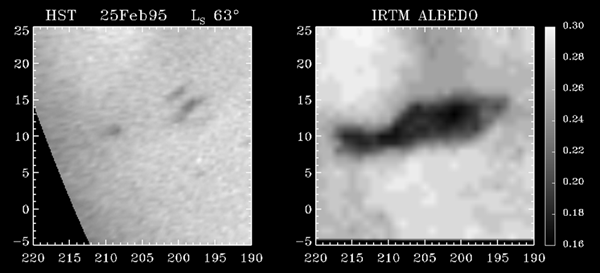