3.1. Observational Requirements
3.2. Mission Constraints
3.3. Methods and Procedures/Anticipated Results
3.3.1 Retrievals of Dust, Cloud, and Ozone Opacities
3.3.1.1. Cloud Opacities
3.3.1.2. Dust Opacities
3.3.1.3. Ozone Opacities
3.3.2. Wide Angle Studies
3.3.3. Medium Angle Studies
Based on the science studies most likely to benefit from observations from the
Mars Surveyor '98 Orbiter, science observational requirements can be
established:
1. Repetitious, global coverage at scales between 1 and 10 km/pixel.
2. Multispectral capability to distinguish between cloud
compositions (water, CO2 ice and dust).
3. UV imaging capability at limb and nadir to observe ozone as a
measure both of atmospheric photochemistry and as a surrogate for
water vapor concentration.
4. Medium resolution (10's meters/pixel) observations of selected areas,
multispectrally, to study specific processes and/or phenomena at local scale
(frost formation and evolution in the polar regions, local dust storm formation
and movement, etc.).
These requirements translate to technical requirements for the MARCI cameras
(Table 2).
Table 2: Science Requirements for MARCI
    Requirement      Wide Angle Camera   Medium Angle Camera

    Resolution       1-10 km/pixel       50 m/pixel
                     nadir, < 7 km limb

   Field of View     limb to limb        nadir, repeat coverage
                                         in timescale << seasonal

   Spectral Bands    ~ 5, including      5-10 bands, 450-1000 nm
                     250 and 330 nm

   MTF @ Nyquist     0.10                0.10

        SNR          >= 20:1, for Albedo = 0.10, at aphelion,
                     with illumination angle (i) <= 75° (sun
                     elevation >= 15° )

    Photometry       5% relative (within an image), 10% absolute
                     (between images)
Table 3: Mars Surveyor '98 Orbiter Mission Constraints for MARCI
Data Volume          Varies by over two orders of magnitude
                     during mission, from 21.5 Mb/day to 3,375
                     Mb/day

Computational        2-18 MIPS, depending on available power;

Resources            fraction of 500 Kb program memory, 40 Kb
                     sequence

Power                18 W available; 28 V unregulated

Mass                 <= 3 Kg

Communications       RS-422, 1 Mb/sec

Thermal              To be determined in conjunction with S/C

Other Physical       As described in PIP
Environments
(Vibration, Shock,
Acoustics,
Acceleration)

Attitude & Control   Control: 25 mrad/axis
(3 sigma)            Knowledge: 25 mrad/axis
                     Stability: 1.5 mrad/1 sec, 3 mrad/12 sec

Radiation            Total dose:  7 Krads/yr at outer surface of
                     instrument from external sources during
                     cruise (assuming 0.1 inch Al shielding)
In addition to the observational requirements, mission parameters also
constrain instrument design. Some of these constraints are operational (e.g.,
the location, altitude, and attitude of the spacecraft as a function of time),
while others are environmental (e.g., the thermal and ionizing radiation
environment). Additionally, there are the constraints imposed on resources,
including mass, power, and downlink data rate. Some of the values given in the
PIP and summarized in Table 3 were taken as guidelines for the various
constrained parameters.
As noted earlier, a unique opportunity exists for using UV imaging to extract
important quantitative information about atmospheric constituents. This
section begins with a more detailed description of the intent of this
particular aspect of this investigation and techniques to be used, before
outlining the broad aspects of other imaging methods and expected results.
The use of combined visible/ultraviolet imaging of Mars has been demonstrated
from HST observations to provide strong constraints on dust, cloud, and ozone
opacities in the Mars atmosphere (James et al., 1994). The key strengths of
the 230-330 nm observations are the low albedos of the Mars surface (0.01-0.02;
Hord et al., 1974) relative to atmospheric Rayleigh scattering, the resulting
sensitivities to small dust and cloud opacities (< 0.05, see below) in nadir
as well as limb viewing, and the ability to observe the Hartley band absorption
of atmospheric ozone as a proxy for Mars atmospheric water vapor (Barth et al.,
1973; James et al., 1994). The combination of MARCI visible and UV limb
imaging discriminates dust from cloud aerosols, and provides vertical profiling
of cloud, dust, and ozone opacities over altitudes of 0-50 km. Each of these
capabilities is described below in terms of specific measurement/retrieval
goals and methods for the MARCI experiment.
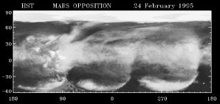
Clouds appear very bright against the dark surface of Mars at violet
and UV wavelengths. Figure 3 presents north-south
cross sections of 230 and 336 nm brightnesses from December 1990 HST
images of Mars (from James et al, 1994), in which the north polar hood
(tau ~0.2) appears roughly 3 times brighter than the surface plus
Rayleigh atmospheric reflectances. Also note the violet image
projection of the low latitude cloud belt observed around Mars
aphelion in 1995, as presented in Figure 4 (from
Clancy et al., 1995). Neither of these large-scale cloud systems are
very apparent in green and red light imaging, and the spatial
variations of such diffuse clouds are not easily separated from the
strong spatial variations of surface albedos at these longer
wavelengths. The very low surface albedos in the UV and the distinct
Rayleigh scattering component of the UV reflectance (note the presence
of the enhanced Rayleigh scattering over Hellas Basin, pixels 125-175
in the 230 nm cross section of Figure 3) provide optimum mapping of
cloud opacities as small as 0.02, from nadir viewing. In limb viewing
geometry, MARCI should obtain the vertical distribution of clouds with
~4 km vertical resolution to altitudes as high as 70 km, depending on
the cloud optical depths and vertical distributions. The combined
UV/visible imaging will also distinguish dust and cloud aerosol
scattering, as described below.

Figure 3: UV reflectance and Column Density of O3
GIF = 181 KBytes
Figure 4: HST image of Mars at 410 nm
Owing to the low UV single scattering albedo of the dust particles
(~0.4-0.6, Pang and Ajello, 1977) and the substantial UV Rayleigh
scattering optical depths of a 6 mbar CO2 atmosphere
(taunadir= 0.03 at 336 nm), dust loading leads to
significant decreases in the UV brightness of the Mars atmosphere.
This effect is most strongly exhibited on the atmospheric limb of
Mars, where the optical columns of molecular scattering and dust
absorption are enhanced. Figure 5 shows an
equatorial cross section of the observed 336 nm limb radiance of the
Mars atmosphere as observed by HST on December 13, 1990 (from James et
al., 1994). Multiple scattering radiative transfer calculations are
presented for two cases incorporating simple surface and atmospheric
molecular scattering (solid line) and surface and atmospheric
molecular scattering with a dust opacity of 0.2 (dashed line). Note
that ozone absorption is not present at 336 nm (see below). These
model calculations only extend to emission angles of 65°, and have
been normalized to the observed radiances at the Mars disk center, to
reflect the uncertain calibration of the WF/PC I UV imaging (James et
al., 1994). At visible wavelengths, dust appears as distinct
atmospheric limb brightening rather than absorption, because the dust
single scattering albedo is high (~0.9) and Rayleigh scattering is
minuscule (e.g., Clancy and Lee, 1991). As a consequence, strong
discriminations of dust versus cloud aerosols are provided from
the combined visible/UV limb observations. Given the spatial
resolution of the MARCI limb measurements (~ 4 km, versus ~50 km for
the HST images, e.g. see cover), sensitivities to minimum dust column
opacities of 0.05, as well as the 0-50 km profile of dust opacity
during high dust loading (tau >1, with approximately 10 km vertical
resolution) should be obtained. However, dust loading in the lower 10
km of the atmosphere must be derived at non-limb tangent viewing owing
to the > unity dust/Rayleigh limb optical depths for the lower
scale height.

Figure 5: UV Reflectance and the Effects of Dust
High latitude determinations of ozone columns are presented
in Figure 3, where the dashed line curve of 230 nm brightness models
the effect of Hartley band ozone absorption on the observed 230 nm
brightnesses. MARCI will use a wavelength of 250 nm, which is more
optimally placed within the Hartley ozone band. Since ozone
absorption is negligible at 330 nm, the determination of Mars
atmospheric ozone opacities will be obtained from the ratio of the
observed 255 and 330 nm radiances. The observed airmass dependence of
the 250 to 330 nm brightness ratio leads to a determination of the
ozone opacity that is fairly insensitive to calibration and modeling
uncertainties. The variation of this ratio on the atmospheric limb
provides for ~one scale height (10 km) resolved profiles of the ozone
absorption over the 0-40 km altitude range, although ozone retrievals
in the lowest scale height must rely on viewing airmasses below the
limb tangent (path lengths of 2-4). MARCI will have the sensitivity
to measure ozone columns of 1 µ m-atm, sufficient to observe the
smaller ozone abundances at low latitudes (~2 µ m-atm, Espenak et al.,
1991) as well as the larger high latitude ozone levels (e.g., Figure
3). Mars atmospheric ozone is photochemically tied to atmospheric
water vapor, such that it varies inversely with atmospheric water
(e.g., Nair et al., 1994). Hence, the observed variations of ozone
provide key information on the seasonal and spatial variations of Mars
atmospheric water. Furthermore, recent observations of low altitude
water vapor saturation around Mars aphelion (Clancy et al., 1995a)
have been correlated with large increases in atmospheric ozone, from
HST 1995 Faint Object Spectrograph observations (Clancy et al.,
1995b). These key aphelion changes in Mars ozone behavior can be
measured in much greater detail by MARCI.

JPG = 105 KBytes
GIF = 642 KBytes
Figure 6: "Worst Case" Daily Global Map Resolution (bottom)
compared to "Best" HST (top)
The primary dataset for study of atmospheric processes on Mars will be provided
by the wide angle camera. Regularly repeated global maps produced by the low
resolution camera will also be the primary data set used for monitoring dust
storm activity and variable features. Frequent multispectral observations will
enhance the science return in all areas of atmospheric and surface/atmospheric
investigations. Wide angle data will be used to characterize the dominant
zonal wave numbers, phase speeds, and meridional structure of baroclinic
systems in both hemispheres by direct measurement of their location on a daily
basis. Likewise, it will be possible to provide daily estimates of wind speed
and direction at locations where clouds and aerosols form, by tracking their
motion on a daily basis in mid- and equatorial latitudes, and on a hourly basis
for latitudes poleward of 60° . Opacity and cloud data should reveal areas
that are persistently dustier and cloudier than others, as predicted by GCMs.
These models also predict that the martian Hadley cell is much more
longitudinally variable than previously thought. In particular, the meridional
flow in the lower branch of the Hadley cell should be channeled into narrow
currents along the eastward flanks of major topographic rises such as Tharsis.
Again, this is a model prediction that will be tested using wide angle data.
The medium angle camera provides the opportunity to examine specific areas and
phenomena at higher spatial and spectral resolution. It will be used to
provide data on the local structure within dust clouds and, if a planet
encircling storm should occur, within that. For dust storm studies, regions in
which dust storms are frequently observed in the historical record (such as
Solis Planum, Isidis Planitia/Syrtis Major, Hellas Planitia, and Hellespontis)
or where MGS or MARCI have observed storm activity will be targeted. Repeated
imaging at several seasons will be acquired both to establish a baseline for
future changes, and to look for changes since previous missions observed these
areas.
The medium angle camera will be used to study particular clouds, such as the W
cloud system in Tharsis/Valles Marineris and the spiral storms (Hunt and James,
1979), in order to understand their structure and evolution. The residual
polar caps will be monitored in order to study the fractional coverage of the
surface and to estimate the thickness of the frost deposits. In addition,
these medium resolution images will enable detailed comparisons with Viking,
Mariner 9, and MGS images at identical seasonal dates in order to address the
issues of interannual differences and evolution of the residual caps. Various
regions near the edge of the seasonal caps will be observed on consecutive days
at medium resolution in order to observe the sublimation (and condensation)
processes as the edge of the cap passes the particular point, and regions in
the cap interior will be observed to test the hypothesis that albedo variations
within the cap are due to fractional coverage of the surface. Specific
locations within the cap such as the Mountains of Mitchel, craters with frost
streaks, and craters with dunes within them will be studied using data from the
medium resolution camera in order to correlate the special behavior of these
regions with local topography and surface properties.
Selected regions poleward of 75° N and 70° S will be photographed both
with single and multiple strips of 4 color coverage. In other areas,
morphological mapping with one color will suffice. Coverage will occasionally
be repeated of certain areas, such as after initial loss of frost. Much of the
polar investigation will be performed in the absence of seasonal frost, which
limits the higher latitude images to short seasons.
For studies of variable features, swaths through a number of regions of noted
variability will be acquired. Candidate locations include swaths through the
center and east and west margins of Syrtis Major Planitia, Cerberus, Solis
Planum, Oxia Palus, and the dark collars surrounding the Tharsis volcanoes.
Multi-season coverage will be necessary to relate observed albedo variability
to any variations in the surface morphology.
To study mid- and low latitude eolian materials, imaging strips taken
through at least 4 filters and up to 200 km long are needed at several
dozen locales. Multi season imaging of half of these areas will be
used to establish the relation of current activity to the underlying
deposit characteristics, and to insure that data include periods of
minimal dust covering and atmospheric interference. Similar strips of
non-eolian morphology will also be acquired.
 Return to MSSS
Home Page
Return to MSSS
Home Page