5.1. Data Processing
5.2. Data Products
5.3. Data Validation/Reduction
5.4. Data Release/Distribution
Each image taken by the MA camera is compressed and transmitted as an
entity independent of any other image. Sequential WA images are
concatenated and compressed in roughly 1000 line chunks. The
lowest-level archival data set will be the compressed version of each
image, decommutated as necessary from the spacecraft data stream and
stored, one image per file. A catalog program developed for the
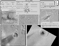
MO/MGS MOC effort (Figure 13) permits easy
viewing of all images (both those in the low-level archive and those
from previous missions) that contain a specified point on the martian
surface. Searches can also be made on the basis properties of the
data (e.g., viewing and illumination geometry, filter, date/time,
resolution, etc.).

GIF = 502 KBytes
Figure 13: Screen view of MOC Browsing Tool, showing Mars Digital Image
Mosaic and Mariner 9 B-frame found by combination of location and resolution
search.
Systematic processing will be applied to each image in the following order:
decompression, noise removal and MTF restoration, and radiometric
calibration.
For the MA images, each image contains ten "framelets", one in each color band.
In general, it will be necessary to build larger, contiguous strips of coverage
in each color, and to be able to examine the data without necessarily applying
map projection, as part of the data validation effort. Relatively simple
modification of the existing MOC software will permit multiple sequential
images to be concatenated into single-color images or multi-color "cubes."
For final generation of geometrically-corrected, map-projected data products,
each image will be processed independently and the results of multiple image
processing runs concatenated together into a mosaic. Distortions caused by
optics and spacecraft motion will be removed concurrently with map projection
to avoid image resampling degradation. Software to perform this processing has
already been developed by MSSS in support of Clementine data processing.
Data products will be created at two levels of processing. The first,
lowest-level archive will consist of one image per file, decommutated from the
spacecraft data stream, but otherwise in the compressed format as transmitted
by the instrument. This archive will be delivered on write-once CD or
high-density cartridge tape as appropriate. Data archived in this format
normally requires significant resources to process into useful form, and is
generally not distributed broadly. Based on a total compressed data return of
225 Gb (28.1 GB), the compressed archive will fit on forty-four 650 MB CD-ROMs
or six 5-GB cartridge tapes. One copy of these data shall be provided to the
Planetary Data System (PDS).
The second and more generally useful product will consist of radiometrically
calibrated mosaics in appropriate map projection. All map and multispectral
data products will adhere to standard PDS formats. Assuming a nominal
compression factor of 5 on returned data, 15 CDs will contain the
low-resolution global maps. About 205 CDs will store the higher-resolution
global color or medium resolution multispectral mosaics of selected areas.
These products will be generated on CD-ROM in a format suitable for replication
and wide distribution. A small number of copies of these CDs will be provided
to the Project and the PDS.
Data validation shall consist of uplink performance assessment (sequence
success analysis), downlink performance assessment and recall request
generation/execution, error logging, inspection for and analysis/understanding
of instrumental problems, calibration performance analysis, and E-Kernel
production. Data reduction is a necessary part of data validation, as it
allows practical details of the quality and usefulness of the data to be
determined. It shall include, but not be limited to, production of selected
data sets for comparison with MOC, TES, and PMIRR observations (to determine
relative and, potentially, absolute calibration from in-flight observations),
mosaics (to determine the ability to identify and correct seams between
observations), and numerically reduced measurements (for comparison with
Earth-based telescopic and PMIRR observations to determine the performance of
MARCI in quantitative analyses).
All products will ultimately be available from the PDS on CD-ROM and via
Internet connections (World Wide Web). A fraction of the raw, unvalidated data
will be available for brief periods of time (limited by downlink data rate and
available data storage volume on the ground). No special effort will be made
to accommodate outside requests for assistance in analyzing these data.
Validated data will be available after relatively brief periods of time during
low data rate periods, also limited by the available on-line storage. However,
during high rate periods, resources are not likely to permit rapid validation
of all the data. During these periods, selected subsets of the data (for
example, the continuous global monitoring coverage) will be given processing
priority.
![]()
 Return to MSSS
Home Page