3. INVESTIGATION APPROACH

    3.1. Observational Requirements
      3.1.1. Resolution
      3.1.2. Landing Site Visibility and Field of View
      3.1.3. Nesting Coverage
      3.1.4. Nesting Scale Ratio
    3.2. Mission Constraints
    3.3. Method and Procedures/Anticipated Results
    3.4. Observational Approach/ Operational Scenario

3.1. Observational Requirements

Table 1 outlines science requirements based on either science or context arguments as noted in the preceding sections. Table 2 outlines mission constraints as imposed by the Announcement of Opportunity and Payload Information Package. Some of these requirements and constraints are discussed in more detail below.

Table 1: Science Requirements for MARDI


Resolution (Highest)        ~2 cm/pixel                                    

Landing site visibility     must be seen in last frame; desire to see      
                            throughout descent                             

Field of View               landing site visible in last frame that        
                            covers >=10 m @ 2 cm/pixel                     

Nesting Coverage            full for anticipated horizontal velocities     
                            (PIP Addendum 1)                               

Nesting Scale Ratio         better than 5:1 (<= 2:1 goal)                  

MTF @ Nyquist               0.10                                           

SNR                         >= 20:1, for Albedo = 0.10, at aphelion,       
                            with illumination angle (i) <= 75° (sun     
                            elevation >= 15° )

Photometry                  5% relative (within an image), 10% absolute    
                            (between images)                               

Images Returned             ~8-16                                          

Spectral Response           500 to 800 nm                                  

Bit Error Rate              5 X 10⁻⁵

3.1.1. Resolution

A resolution goal of 2 cm/pixel was deemed necessary to adequately characterizethe local environment of the lander. It is unlikely that a surface camera will be able to place the lander in local context as well as a camera looking down from above the surface. Both the highly oblique viewing geometry and the likely presence of obstacles makes reliance solely on a surface camera subsystem for such context, risky. The 2 cm/pixel requirement is also technically reasonable given present CCD pixel size and number, and other requirements outlined below for viewing the actual landing site.

3.1.2. Landing Site Visibility and Field of View

The requirement to view the landing site throughout the descent directly constrains the FOV, as does the areal coverage and resolution of the last frame (10 m at 1-2 cm/pixel). High horizontal relative to vertical velocities, pendulum sway while descending beneath the parachute, and the desire for oblique viewing geometry over part of the field (to provide stereoscope coverage as well as a visual impression of relief) argue for a wide field of view. Rapid descent and small pendulum swing argue for a narrow field of view. Although the Mars Surveyor '98 Lander descends very rapidly (See Section 3.3.), uncertainties in pendulum swing and horizontal wind speeds during the descent from 8 km to 1.5 km argues for a wide field of view.

3.1.3. Nesting Coverage

Nesting coverage is the way successive images relate to one another, and to the entire suite of images. Full nesting means that all higher resolution images are fully contained within the lowest resolution image (Figure 1, right). This provides a direct view of a small, localized area (including the landing site) at all resolutions down to the surface, and occurs when, for example, the descent is entirely vertical. The rapid Mars Surveyor '98 Lander descent makes full-nesting relatively easy to achieve.

3.1.4. Nesting Scale Ratio

The nesting scale or resolution ratio is determined at the beginning of descent imaging by the altitude at which imaging starts and by the descent rate, and at the end of the descent by the descent rate, the minimum time between frames, and the available buffer space. An optimized solution would have a variable nesting ratio, but practical requirements suggest that a single ratio be used throughout the descent. For illustrative purposes, and based on the (relatively arbitrary) data volume limit of 37 Mbits, a ten frame sequence acquired at a ratio of roughly 2:1 (modulated primarily by the one-every-other-second read-out speed) is illustrated in this proposal (see Section 3.3. and Table 3, below).

3.2. Mission Constraints

In addition to the observational requirements, mission parameters also constrain instrument design. Some of these constraints are operational (e.g., the location, altitude, and attitude of the spacecraft as a function of time), while others are environmental (e.g., the thermal and ionizing radiation environment). Additionally, there are the constraints imposed on resources, including mass, power, and downlink data rate. Some of the values given in the PIP and summarized in Table 2 were taken as guidelines for the various constrained parameters.

Table 2: Mars Surveyor '98 Lander Mission Constraints for MARDI


Descent Rate/Duration       80 sec to descend 8 km, 30 sec to descend      
                            last 1.4 km                                    

Downrange Distance          < 2  km in 80 sec, < 500 m in last 30 sec

Pendulum Angle              <= 15° 

Data Volume                 37 Mbits (Mb) (equivalent to 1 transmission    
                            to relay)                                      

Computational Resources     <= 2 MIPS during descent; fraction of 500 Kb   
                            EEPROM, 1 Mb SRAM for software                 

Power                       5 W total science during descent; 28 V         
                            unregulated                                    

Mass                        Fraction of 20 Kg total payload mass           

Communications              RS-422, 1 Mb/sec (2 available)                 

Thermal                     Cruise: -20° to +30° ; Operations:        
                            -40° to +30° C                            

Other Physical              As described in PIP                            
Environments (Vibration,                                                   
Shock, Acoustics,                                                          
Acceleration)                                                              

Monopropellant Engine       30° cones, 5 m in length; optically         
Plume                       transparent; thermal distortion TBD            

Radiation                   Total dose:  ~2,500 rads at outer surface of   
                            instrument from external sources during        
                            cruise (assuming 0.1 inch Al shielding from    
                            spacecraft)                                    

3.3. Method and Procedures/Anticipated Results

MARDI acquires images every two seconds from the time the aeroshell is released until the spacecraft lands. A fixed exposure/fixed aperture system is employed, with the detector full-well tuned to the anticipated range in illumination conditions. The large dynamic range is accommodated by square-root encoding (video compress/expand = companding). Quarter-millisecond exposures provide smearless images at all altitudes during the descent. Each image is read off the detector in just under two seconds, with companding, analog-to-digital conversion, video correction, and lossless data compression occurring in realtime. The data are transmitted to the spacecraft for storage, where a sieving algorithm selects from the acquisitions those that meet the nesting resolution ratio criteria, retains these and releases storage for future images (an alternative strategy uses the spacecraft's knowledge of altitude from the altimeter to trigger image acquisitions, but use of this strategy must await more detailed knowledge of the spacecraft). MARDI software running on the spacecraft central processing unit (CPU) decompresses the images and recompresses them using a lossy compressor, to reduce the volume to be transmitted to Earth. Depending on the downlink availability and long-term storage available, the lossless data may be retained for ultimate transmission to Earth.

Upon receipt on Earth, the images are decompressed and pre-flight photometric and geometric corrections are applied. Science analyses will include extraction of relief from stereo images and production of maps of the landing site in near-realtime in support of lander operations. A highlight of the data processing will be the recreation of the descent in animated form.

Table 3: Representative Descent Image Acquisition Scenario


 Time   Altitude   Image Size   Resolution    Compress.    Cumulative Data   
 (sec)     (m)         (m)         (cm)        Factor          Vol. (Mb)     

   72     6,750       8,647        865          10:1             8.39  
   50     3,368       4,315        431          10:1            12.58  
   34     1,668       2,137        214          10:1            16.78  
   24       862       1,104        110          10:1            20.97  
   18       470         602         60.2        10:1            25.17  
   12       198         254         25.4         2:1            29.36  
    8        82         105         10.5         2:1            33.55  
    6        44          56         5.64         2:1            34.39  
    4        19          24         2.43         2:1            35.23  
    2         7           9         0.90         2:1            36.07  

Under nominal circumstances, and limited by the available storage volume, ten 1000 X 1000 pixel images will be acquired from altitudes below 8 km. More images could be returned if data volume were available. Table 3 provides representative information about these images from an example operational scenario. In general, the first image will cover about 8-9 km on a side at a resolution of about 8-9 m/pixel, and the worst case last image (acquired 2 seconds before landing), will cover an area just under 9 m across at 0.9 cm/pixel.

In addition to the individual images, derived information will include:

3.4. Observational Approach/ Operational Scenario

Descent image acquisition will be keyed to the descent ground and time profile. Figure 4 shows the descent profile, at two scales, as determined from information provided in the PIP and QA2 Attachment 1 (MSP Lander Terminal Descent Profile). The left hand graph shows the profile from aeroshell deployment to touchdown in two second increments (circles), with image acquisitions indicated by filled circles. The total descent takes roughly 80 seconds, with the last 30 seconds under monopropellant engine power. During the first 50 seconds, the pitch angles are relatively low (the lander is suspended beneath the parachute) and the horizontal velocity increases slightly owing to wind interactions in the thickening atmosphere. Shortly after powered descent begins, the lander is pitched so that its thrust vector is aligned with the descent velocity vector, and the two vectors are matched throughout the terminal descent. The descent is nearly vertical during the last 200 m.

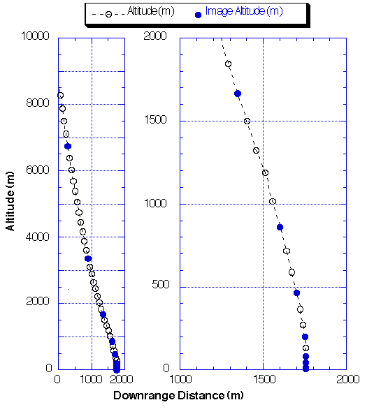
Figure 4: Mars Surveyor '98 Descent Profile and Descent Imager Data Acquisitions

The descent imaging sequence begins when the instrument is powered-up and the spacecraft CPU boots the camera software around the time of parachute deployment. Acquisition of nested images begins as soon as the aeroshell is jettisoned, approximately 10 seconds later (altitude ~6 km). Images at that altitude will cover just under 75 km2 at a resolution of 8.5 m/pixel. A sieving algorithm (or alternatively, altimeter-triggered acquisitions) will be employed to acquire images at known scale intervals. Observations at a scale ratio of 2 would yield a data set summarized in Table 3, and illustrated by the image sequence shown in Figures 1-3 (except for the last four frames). Both lossless and lossy software compression are applied to fit the sieving fractions and selected frames within the 37 Mb constraint; acquisitions triggered by the altimeter could be retained in losslessly compressed format. Following the landing, images would be compressed for "quicklook" transmission to Earth via either direct or relay links. Owing to its short operational life, MARDI operations will be conducted by the same Malin Space Science Systems staff responsible for operating the Mars Global Surveyor Relay (the MR uses the Mars Orbiter Camera solid state buffer and error encryption processing), using software developed to support the Mars '96 landers. This will insure that the data are acquired during the first available relay pass. Data processing will be conducted in "receipt realtime," and released for public dissemination and scientific analysis.


To MARCI Table of Contents

To Previous Section

To Top of This Section

To Next Section

Return to Mars Page

Return to MSSS Home Page